|
Size: 194
Comment:
|
Size: 989
Comment:
|
| Deletions are marked like this. | Additions are marked like this. |
| Line 1: | Line 1: |
| = LMRK_POS = |
|
| Line 2: | Line 4: |
| This code package generates the sun and spacecraft position with respect to a selected landmark when an image from the the spacecraft is taken with the landmark in it. | This code package generates the sun and spacecraft position with respect to a selected landmark during imaging capture of the selected landmark. The position in terms of azimuth, elevation, and zenith angles from a topocentric SEZ (South East Zenith) frame. For visual representation, polar plots are outputed that show the zenith angle and azimuth of the sun and spacecraft when images are taken of the chosen landmark. == Codes and Text Files == This package includes two codes and multiple text files. Some of the textiles are created by the user and others are outputted from a code. Below is a flow chart that details the process of using the codes. LMRKNAMES.txt - a txtfile the user makes that consists of of one column list of the landmarks to be analyzed. POS_SCRIPT.sh - shell script that uses LMRKNAMES.txt to make LAT.txt, LON.txt, NUMBERPIC.txt, RESIDUALS.txt, PICTIMES.txt {{attachment:LMRK_SUN_SC_POS.jpg||width=800}} |
LMRK_POS
Basic Description
This code package generates the sun and spacecraft position with respect to a selected landmark during imaging capture of the selected landmark. The position in terms of azimuth, elevation, and zenith angles from a topocentric SEZ (South East Zenith) frame. For visual representation, polar plots are outputed that show the zenith angle and azimuth of the sun and spacecraft when images are taken of the chosen landmark.
Codes and Text Files
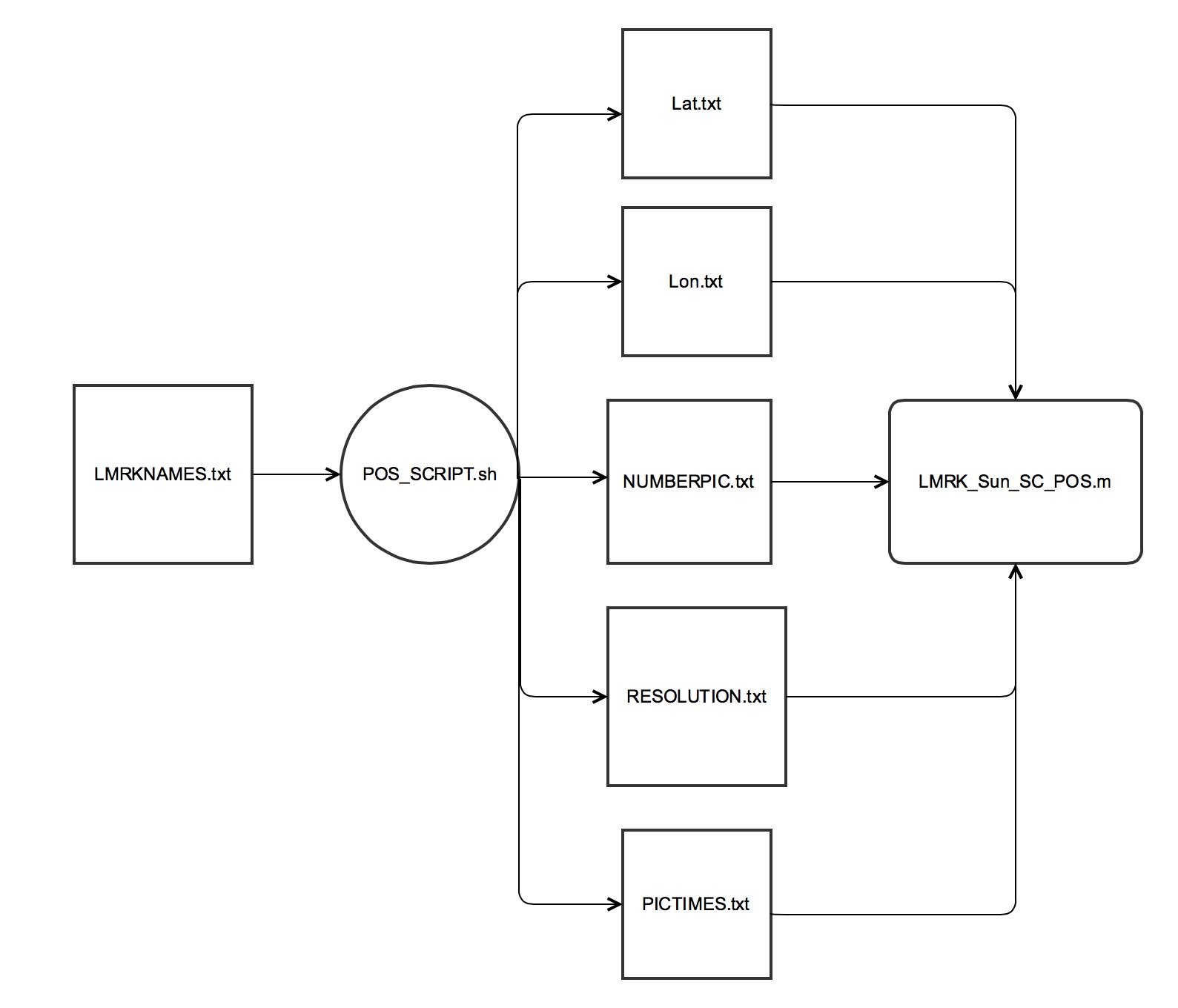
This package includes two codes and multiple text files. Some of the textiles are created by the user and others are outputted from a code. Below is a flow chart that details the process of using the codes.
LMRKNAMES.txt - a txtfile the user makes that consists of of one column list of the landmarks to be analyzed.
POS_SCRIPT.sh - shell script that uses LMRKNAMES.txt to make LAT.txt, LON.txt, NUMBERPIC.txt, RESIDUALS.txt, PICTIMES.txt 
