|
Size: 871
Comment:
|
← Revision 17 as of 2016-08-04 07:32:53 ⇥
Size: 5960
Comment:
|
| Deletions are marked like this. | Additions are marked like this. |
| Line 5: | Line 5: |
| * center at -40,135 (lat,lon) * scale = 1 km/px |
* center at 45, 270 (lat,wlon) * scale = .00075 km/px |
| Line 8: | Line 8: |
| * name = ‘LMK000’ * Then we will tile LMK000 with 9 overlapping better resolution maplets (LMK001-LMK009) |
* name = ‘TEST01’ * Then we will tile TEST01 with 9 overlapping better resolution maplets (LMK001-LMK009) |
| Line 12: | Line 12: |
| * ''' LITHOS.e''' | * ''' lithos''' |
| Line 14: | Line 14: |
| * '''LMK000''' - landmark name | * '''TEST01''' - landmark name |
| Line 16: | Line 16: |
| * '''-45,135''' - lat, lon * '''1,49''' - enter scale (km/px), qsz |
* '''45 270''' - lat, lon * '''.00075,49''' - enter scale (km/px), qsz |
| Line 19: | Line 19: |
| * '''LMK000''' - landmark name (as previously named) | * '''TEST01''' - landmark name (as previously named) |
| Line 24: | Line 24: |
| * In a second terminal: * cd Vesta *ls-Irt * display LMRK_Display1.pgm |
In a second terminal: {{{ cd Bennu ls -lt | head display LMRK_Display1.pgm }}} You can also use the SPC_Tools: landmarks === LITHOS: Eliminate Pictures from Landmark === * '''e''' - eliminate pictures from landmark * '''n''' - auto-eliminate new images only (a for auto-eleiminate) * '''0,50,.2,.2,0,4''' - Input INVLIM,SLIM,CLIM,ILIM,RSMN,RSMX {{attachment:lesson2_EliminatePicsFromLandmark.jpg||width=600}} {{attachment:lesson2_EliminatePicsFromLandmark2.jpg||width=600}} * INVLIM = 1000 * MAX INVISIBLE FRACTION (0-1000) * SLIM = MAX EMISSION ANGLE (0-90) * CLIM = MIN FRACTION OF VISIBLE (0-1) * ILIM = MIN FRACTION IN SHADOW (0-1) * RSMN = MIN IMGSCALE/MAPSCALE (0-inf) * RSMX = MAX IMGSCALE/MAPSCALE (0-inf) =>set according to printout and LMRK_DISPLAY * Most permissible: 1000,90,0,0,0,inf => does not throw any image away * Least permissible: 0,0,1,1,inf,0 => throws all away * display LMRK_DISPLAY1.pgm === LITHOS: Get Heights from Shape and Find Normal, V === * '''m''' - get heights from shape model * '''n''' - find normal * '''2''' - normal from heights * '''m''' - get heights from shape model * '''u''' - update landmark file (save) * '''1''' - save map In 2nd terminal: {{{ cd Bennu ls -lt | head display LMRK_Display1.pgm more LMRKLIST.TXT more LMKFILES/TEST01.LMK more MAPFILES/TEST01.MAP showmap TEST01 }}} Then display the TEST01.pgm (xv, imageMagick, convert, GraphicConverter) {{attachment:lesson2_GettingHeights.jpg||width=300}} === LITHOS: Align Landmarks in Pictures === || Option 1. Use this when the template you see in LMRK_DISPLAY1.pgm is poor || Option 2 (typical). Use this as much as you can || || '''1''' - align landmarks || '''1''' - align landmarks || || '''3''' - align with picture || '''0''' - align with template || || '''23''' - picture #2 in LMRK_DISPLAY || '''3''' - enter spacing || || '''1''' - enter spacing || '''n''' - new spacing? || || '''y''' - new spacing? Yes b/c it only aligned a few images || '''0''' - continue || || '''2''' - enter spacing || '''y''' - update landmark pixel locations? || || '''y''' - new spacing? Yes b/c it only aligned a few images || '''1''' - align landmarks || || '''3''' - enter spacing || '''0''' - align with template || || '''y''' - new spacing? Yes b/c 3 caused a couple images to shift>10px || '''1''' - enter spacing || || '''2''' - enter spacing || '''n''' - new spacing? || || '''n''' - new spacing? No, lets just use the correlated images first || '''0''' - continue || || '''0''' - continue || '''y''' - update landmark pixel locations? || || '''y''' - update landmark pixel locations? || || || '''1''' - align landmarks || || || '''3''' - align with picture || || || '''1''' - picture #2 from last iteration became picture #1 || || || '''1''' - enter spacing || || || '''n''' - new spacing? || || || '''0''' - continue || || || '''y''' - update landmark pixel locations? || || display LMRK_Display1.pgm === LITHOS: Find Template === * '''u''' - update landmark file (save) * '''1''' - Save map * '''0''' - find template * '''c''' - use correlated * '''.7''' - enter correlation limit * '''0''' - find template * '''0''' - continue * '''40''' - number of iterations display LMRK_Display.pgm === LITHOS: Align Landmarks and Find Template === * '''1''' - align landmarks * '''0''' - auto align * '''1''' - enter spacing * '''y''' - new spacing? * '''2''' - enter spacing * '''n''' - new spacing? * '''0''' - continue * '''y''' - update landmark pixel locations? * '''1''' - align landmarks * '''0''' - auto align * '''1''' - enter spacing * '''n''' - new spacing? * '''0''' - continue * '''y''' - update landmark pixel locations? display LMRK_Display1.pgm * '''0''' - find template * '''c''' - use correlated * '''.7''' - enter correlation limit * '''0''' - find template * '''0''' - continue * '''40''' - number of iterations display LMRK_DISPLAY1.pgm REPEAT ONCE === LITHOS: Solve for Heights === * '''2''' - find heights * '''8''' - fill with shape * '''2''' - include existing heights * '''.01''' - input fraction of points * '''1''' - auto include neighboring maps * '''4''' - include limb vectors * '''1,2.5,3''' - input expansion, res/scale limit, d_hgt limit * '''6''' - include differential stereo * '''y''' - use gradients? * '''y''' - autoheights? * '''0''' - begin iteration * '''.025''' - input weight * '''30''' - enter number of iterations * '''0''' - end iterations display LMRK_DISPLAY1.pgm display slope.pgm === LITHOS: Final Alignment and Save === * '''1''' - align landmarks * '''0''' - auto align * '''1''' - enter spacing * '''n''' - new spacing? * '''0''' - continue * '''y''' - update landmark pixel locations? *# We are skipping V-4 for now. You add this when the model is stable *# '''v''' - find V,Z,PTG *# '''4''' - PTG/SCOBJ from Z and V (current images) * '''u''' - update landmark file (save) * '''1''' - save map |
Lesson 2
Objectives
- First we will generate a maplet with the following parameters:
- center at 45, 270 (lat,wlon)
- scale = .00075 km/px
- size = 99 x 99 px or 99 x 99 km
- name = ‘TEST01’
- Then we will tile TEST01 with 9 overlapping better resolution maplets (LMK001-LMK009)
LITHOS: Create New Landmark
lithos
c - create new landmark name
TEST01 - landmark name
l - define landmark control point by specifying a latitude and longitude on the body
45 270 - lat, lon
.00075,49 - enter scale (km/px), qsz
i - input landmark
TEST01 - landmark name (as previously named)
y - check for images?
0.5 - fractional width
n - reject invisibles
In a second terminal:
  cd Bennu
  ls -lt | head
  display LMRK_Display1.pgm
You can also use the SPC_Tools: landmarks
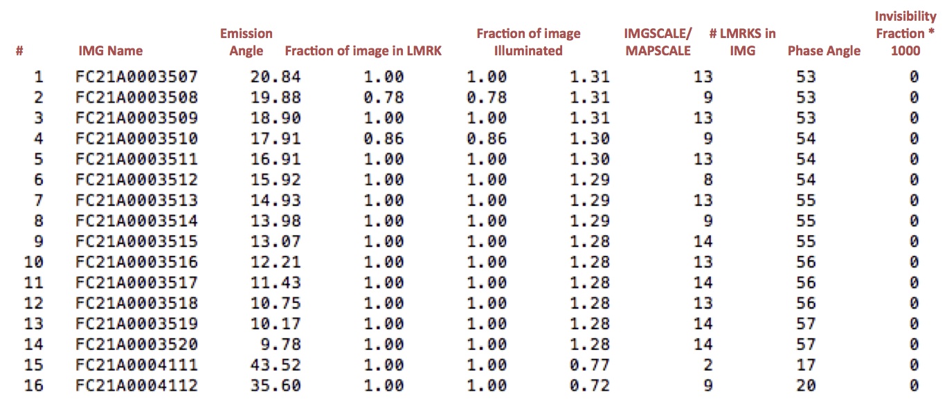
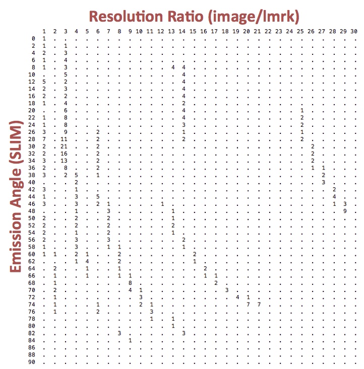
LITHOS: Eliminate Pictures from Landmark
e - eliminate pictures from landmark
n - auto-eliminate new images only (a for auto-eleiminate)
0,50,.2,.2,0,4 - Input INVLIM,SLIM,CLIM,ILIM,RSMN,RSMX


- INVLIM = 1000 * MAX INVISIBLE FRACTION (0-1000)
- SLIM = MAX EMISSION ANGLE (0-90)
- CLIM = MIN FRACTION OF VISIBLE (0-1)
- ILIM = MIN FRACTION IN SHADOW (0-1)
- RSMN = MIN IMGSCALE/MAPSCALE (0-inf)
RSMX = MAX IMGSCALE/MAPSCALE (0-inf) =>set according to printout and LMRK_DISPLAY
Most permissible: 1000,90,0,0,0,inf => does not throw any image away
Least permissible: 0,0,1,1,inf,0 => throws all away
- display LMRK_DISPLAY1.pgm
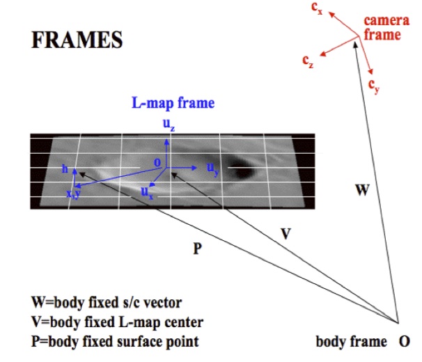
LITHOS: Get Heights from Shape and Find Normal, V
m - get heights from shape model
n - find normal
2 - normal from heights
m - get heights from shape model
u - update landmark file (save)
1 - save map
In 2nd terminal:
  cd Bennu
  ls -lt | head
  display LMRK_Display1.pgm
  more LMRKLIST.TXT
  more LMKFILES/TEST01.LMK
  more MAPFILES/TEST01.MAP
  showmap
      TEST01
Then display the TEST01.pgm (xv, imageMagick, convert, GraphicConverter)

LITHOS: Align Landmarks in Pictures
Option 1. Use this when the template you see in LMRK_DISPLAY1.pgm is poor |
Option 2 (typical). Use this as much as you can |
1 - align landmarks |
1 - align landmarks |
3 - align with picture |
0 - align with template |
23 - picture #2 in LMRK_DISPLAY |
3 - enter spacing |
1 - enter spacing |
n - new spacing? |
y - new spacing? Yes b/c it only aligned a few images |
0 - continue |
2 - enter spacing |
y - update landmark pixel locations? |
y - new spacing? Yes b/c it only aligned a few images |
1 - align landmarks |
3 - enter spacing |
0 - align with template |
y - new spacing? Yes b/c 3 caused a couple images to shift>10px |
1 - enter spacing |
2 - enter spacing |
n - new spacing? |
n - new spacing? No, lets just use the correlated images first |
0 - continue |
0 - continue |
y - update landmark pixel locations? |
y - update landmark pixel locations? |
|
1 - align landmarks |
|
3 - align with picture |
|
1 - picture #2 from last iteration became picture #1 |
|
1 - enter spacing |
|
n - new spacing? |
|
0 - continue |
|
y - update landmark pixel locations? |
|
display LMRK_Display1.pgm
LITHOS: Find Template
u - update landmark file (save)
1 - Save map
0 - find template
c - use correlated
.7 - enter correlation limit
0 - find template
0 - continue
40 - number of iterations
display LMRK_Display.pgm
LITHOS: Align Landmarks and Find Template
1 - align landmarks
0 - auto align
1 - enter spacing
y - new spacing?
2 - enter spacing
n - new spacing?
0 - continue
y - update landmark pixel locations?
1 - align landmarks
0 - auto align
1 - enter spacing
n - new spacing?
0 - continue
y - update landmark pixel locations?
display LMRK_Display1.pgm
0 - find template
c - use correlated
.7 - enter correlation limit
0 - find template
0 - continue
40 - number of iterations
display LMRK_DISPLAY1.pgm
REPEAT ONCE
LITHOS: Solve for Heights
2 - find heights
8 - fill with shape
2 - include existing heights
.01 - input fraction of points
1 - auto include neighboring maps
4 - include limb vectors
1,2.5,3 - input expansion, res/scale limit, d_hgt limit
6 - include differential stereo
y - use gradients?
y - autoheights?
0 - begin iteration
.025 - input weight
30 - enter number of iterations
0 - end iterations
display LMRK_DISPLAY1.pgm display slope.pgm
LITHOS: Final Alignment and Save
1 - align landmarks
0 - auto align
1 - enter spacing
n - new spacing?
0 - continue
y - update landmark pixel locations?
- # We are skipping V-4 for now. You add this when the model is stable
# v - find V,Z,PTG
# 4 - PTG/SCOBJ from Z and V (current images)
u - update landmark file (save)
1 - save map
