|
Size: 1091
Comment:
|
Size: 3022
Comment:
|
| Deletions are marked like this. | Additions are marked like this. |
| Line 9: | Line 9: |
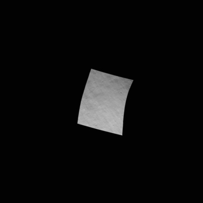
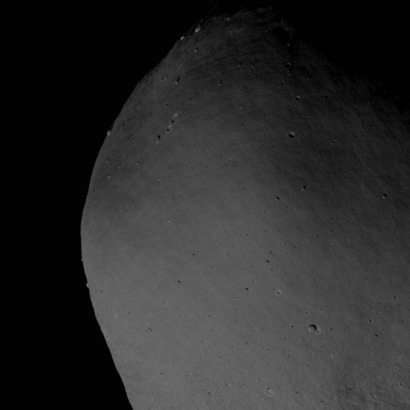
| Images are generated using the following set of dirty sumfiles at the required resolution: | '''Model (left), Truth (right), S/C Azimuth 0, Zenith 30deg, Sun Azimuth 90deg, Zenith 45deg:'''<<BR>> {{attachment:PBF6TG3A0001_MTG101_resized40pt.jpg}} {{attachment:P2F6TG3A0001_resized40pt.jpg}} Images are generated using the following set of dirty sumfiles at the required resolution to include: * low and high phase * low and moderate incidence * full set of s/c azimuth angles (observe region from all directions). |
| Line 22: | Line 29: |
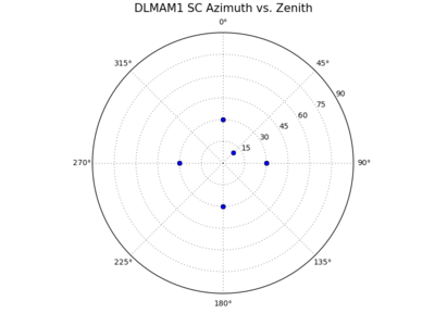
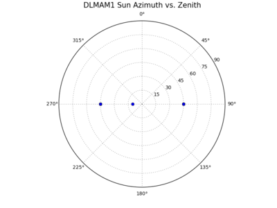
| * Spacecraft Azimuth (degrees): 0, 90, 180, 270, 0, 90, 180, 270, 45 * Spacecraft Zenith (degrees): 30, 30, 30, 30, 30, 30, 30, 30, 10 * Sun Azimuth (degrees): 90, 90, 90, 90, 270, 270, 270, 270, 270 * Sun Zenith (degrees): 45, 45, 45, 45, 45, 45, 45, 45, 10 |
{{attachment:DLMAM1_sc_plot_resized50pt.png}} {{attachment:DLMAM1_sun_plot_resized50pt.png}} |
| Line 28: | Line 33: |
| * Resolution: 120cm, 75cm, 35c,m 18cm, 9cm, 5cm. | * Resolution: 120cm, 75cm, 35cm, 18cm, 9cm, 5cm. |
| Line 30: | Line 35: |
| == Obtain | The following regions have been identified for evaluation: ||Region ID||Region Name||Latitude (deg)||West Longitude (deg)||Description|| ||TG||TAG Site 1||-10||350||Shape 4 TAG site 1|| ||R1||Region 1||45||300||Region of roughness, identified from a visual inspection using Small Body Mapping Tool|| == Where are the Dirty Sumfiles and Truth Images? == '''SUMFILES:''' {{{ormacsrv1:/opt/local/spc/shape4/imageGen/DIRTYSUMFILES/}}}<<BR>> '''Truth .pgm files:''' {{{ormacsrv1:/opt/local/spc/shape4/imageGen/PGMFILES/}}} Follow this link for details of the image file and bigmap naming conventions: [[Normalized Cross-Correlation Evaluation - Naming Conventions]] == Obtain Model Bigmap == Obtain the required bigmap/s from the model working directory (or back-up). A full set of bigmap .in files is stored here: {{{ /opt/local/spc/shape4/support4/ MR1051_model_REG1_GSD5cm_width100m.in MR1052_model_REG1_GSD5cm_width20m.in MR1055_model_REG1_GSD5cm_width50m.in MR1101_model_REG1_GSD10cm_width100m.in MR1102_model_REG1_GSD10cm_width20m.in MR1105_model_REG1_GSD10cm_width50m.in MR1351_model_REG1_GSD35cm_width100m.in MR1352_model_REG1_GSD35cm_width20m.in MR1355_model_REG1_GSD35cm_width50m.in MTG051_model_TAG1_GSD5cm_width100m.in MTG052_model_TAG1_GSD5cm_width20m.in MTG055_model_TAG1_GSD5cm_width50m.in MTG101_model_TAG1_GSD10cm_width100m.in MTG102_model_TAG1_GSD10cm_width20m.in MTG105_model_TAG1_GSD10cm_width50m.in MTG351_model_TAG1_GSD35cm_width100m.in MTG352_model_TAG1_GSD35cm_width20m.in MTG355_model_TAG1_GSD35cm_width50m.in }}} /Volumes/Data1/spc-test/ /Volumes/Data1/spc-test/F6-evaluation == Populate Evaluation Directory == == Generate Model Images == == Conduct Normalized Cross-Correlation == |
Normalized Cross-Correlation Evaluation
This page describes the methodology for using normalized cross-correlation to evaluate a region of the model.
Cross-correlation is performed on the following images:
- Model: Image of bigmap
- Truth: Image of Zmaps
Model (left), Truth (right), S/C Azimuth 0, Zenith 30deg, Sun Azimuth 90deg, Zenith 45deg:


Images are generated using the following set of dirty sumfiles at the required resolution to include:
- low and high phase
- low and moderate incidence
- full set of s/c azimuth angles (observe region from all directions).
Spacecraft |
Sun |
||
Azimuth (deg) |
Zenith (deg) |
Azimuth (deg) |
Zenith (deg) |
0 |
30 |
90 |
45 |
90 |
30 |
90 |
45 |
180 |
30 |
90 |
45 |
270 |
30 |
90 |
45 |
0 |
30 |
270 |
45 |
90 |
30 |
270 |
45 |
180 |
30 |
270 |
45 |
270 |
30 |
270 |
45 |
45 |
10 |
270 |
10 |


Images resolution is chosen from the following based on the state of the model:
- Resolution: 120cm, 75cm, 35cm, 18cm, 9cm, 5cm.
The following regions have been identified for evaluation:
Region ID |
Region Name |
Latitude (deg) |
West Longitude (deg) |
Description |
TG |
TAG Site 1 |
-10 |
350 |
Shape 4 TAG site 1 |
R1 |
Region 1 |
45 |
300 |
Region of roughness, identified from a visual inspection using Small Body Mapping Tool |
Where are the Dirty Sumfiles and Truth Images?
SUMFILES: ormacsrv1:/opt/local/spc/shape4/imageGen/DIRTYSUMFILES/
Truth .pgm files: ormacsrv1:/opt/local/spc/shape4/imageGen/PGMFILES/
Follow this link for details of the image file and bigmap naming conventions: Normalized Cross-Correlation Evaluation - Naming Conventions
Obtain Model Bigmap
Obtain the required bigmap/s from the model working directory (or back-up). A full set of bigmap .in files is stored here:
/opt/local/spc/shape4/support4/

MR1051_model_REG1_GSD5cm_width100m.in
MR1052_model_REG1_GSD5cm_width20m.in
MR1055_model_REG1_GSD5cm_width50m.in
MR1101_model_REG1_GSD10cm_width100m.in
MR1102_model_REG1_GSD10cm_width20m.in
MR1105_model_REG1_GSD10cm_width50m.in
MR1351_model_REG1_GSD35cm_width100m.in
MR1352_model_REG1_GSD35cm_width20m.in
MR1355_model_REG1_GSD35cm_width50m.in
MTG051_model_TAG1_GSD5cm_width100m.in
MTG052_model_TAG1_GSD5cm_width20m.in
MTG055_model_TAG1_GSD5cm_width50m.in
MTG101_model_TAG1_GSD10cm_width100m.in
MTG102_model_TAG1_GSD10cm_width20m.in
MTG105_model_TAG1_GSD10cm_width50m.in
MTG351_model_TAG1_GSD35cm_width100m.in
MTG352_model_TAG1_GSD35cm_width20m.in
MTG355_model_TAG1_GSD35cm_width50m.in
/Volumes/Data1/spc-test/
/Volumes/Data1/spc-test/F6-evaluation
Populate Evaluation Directory
Generate Model Images
