|
Size: 6089
Comment:
|
Size: 6089
Comment:
|
| Deletions are marked like this. | Additions are marked like this. |
| Line 154: | Line 154: |
| {{attachment:lithos_ExtractingImageData2.jpg||width=600}} | {{attachment:lithos_ExtractingImageData1.jpg||width=600}} |
lithos
Aligns maplets to the current shape model and will provide slight changes to the shape (stored in MAPFILES).
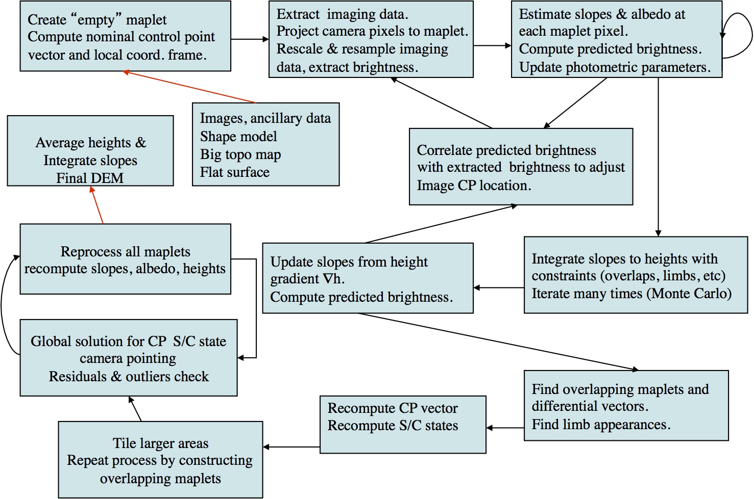
Lithos is the key for SPC. It works on a single landmark, which defined the associated maplet. This landmark must be created (i.e. fully defined) and all the images that include it must be shifted so that everything is aligned. Once those are done, you can calculate the topography which includes identify other maps that overlap, creating a template, and then solving the whole system.
Lithos and LithosP are used by make_script(P) for batch processing. The mark_script program will create a script for each landmark that you will process, which is taken as input (e.g. lithos < LAND01.IIN > LAND01.OOT)
Build a template
- Option 0
Align images
- Option 1
Calculate topography
- Option 2
Housekeeping functions
- Option c - create a landmark
- Option i - "input" a landmark. Basically, start using the landmark.
- Option e - eliminate
- - Good values to use, "0 40 0.2 0.2 0 2"
- - Based on: Input INVLIM, SLIM, CLIM, ILIM, RSMN, RSMX
- INVLIM
- Fraction of the landmark that is obscured by other objects (that is in front)
- 1000 * max invisible fraction (0-1000).
- Suggested: 0
- 0 keeps everything
- SLIM
- Emission Angle: drop if greater than (0-90 degrees).
- Suggested: 40, eliminate images with big emissions angles.
- 90 keeps everything
- CLIM
- How much of the maplet is visible: Drop if less than (0-1.0).
- Suggested: 0.2, the image must only contain 20% of the maplet.
- 0 keeps everything
- ILIM
- How much of maplet is in shadows, drop if more than (0-1.0).
- Suggested: 0.2, the image cannot have more than 20% in shadow.
- 0 keeps everything
- RSMN
- Minimum ratio of the image to maplet, drop if less than (0 to inf).
- Suggested: 0, accept the highest resolution images you can.
- 0 keeps everything
- RSMX
- Maximum ratio of the image to maplet, drop if less than (0 to inf).
- Suggested: 2, reject images with less than twice the resolution of your maplet.
- 999999 keeps everything
Input - optional file
- aaa.INN - a script that sends batch commands
Input - stdin
- Basic steps
- Create a landmark, "C"
- Input a landmark (really that is selecting it for use), "I"
- Creating a template (the virtual idea of the topography and albedo based on the maplets), 0, 0, 40
- Aligning the maplets (0 for auto, 1 for manual, 2 for move all maplets, 3 to align to a specific maplet)
- Update and save, "U 1"
Output
- aaa.OOT
- landmark and map files
- LMRK_DISPLAY0.pgm
- LMRK_DISPLAY1.pgm -- stretched version
- slopeb.pgm - shows slope both in x and y
PowerPoint Notes
Description
- Creates landmark files, determines landmark topography (MAPFILE), and locates landmark center in images
Inputs
- INIT_LITHOS.TXT
- SUMFILESR
- SPC IMG
- NOMINALS
- SPICE
- MAPLETSL
Outputs
- SUMFILESL
- LMKFILESL
- MAPLETSL
- LMRKLIST.TXT
Process Overview
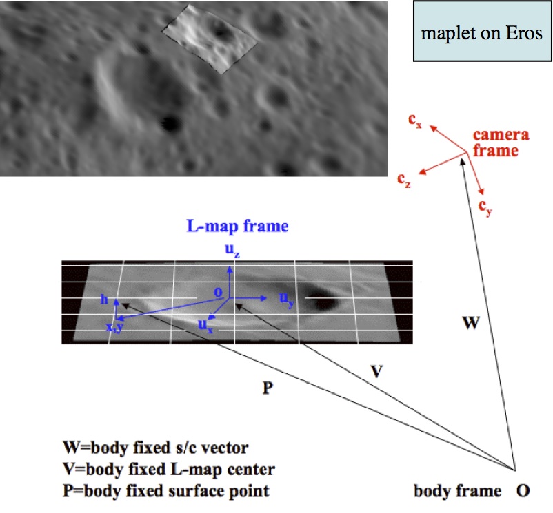
Maplet Definition
3D topography & relative albedo model of a portion of the surface
Control vector V from body center to origin of local coordinate system
- Local coordinate system axes ui(i=1, 3) with u3 normal to the local surface
- 2-D grid, typically 99x99 pixels with positions x=(x1, x2) relative to origin
- Local heights h(x1, x2) and relative albedos a(x1, x2) at each grid point
Camera coordinate system ci(i=1, 3) and S/C position W
- Maplet control point not tied to a specific surface feature
- Maplet pixel scale not tied to specific image resolution
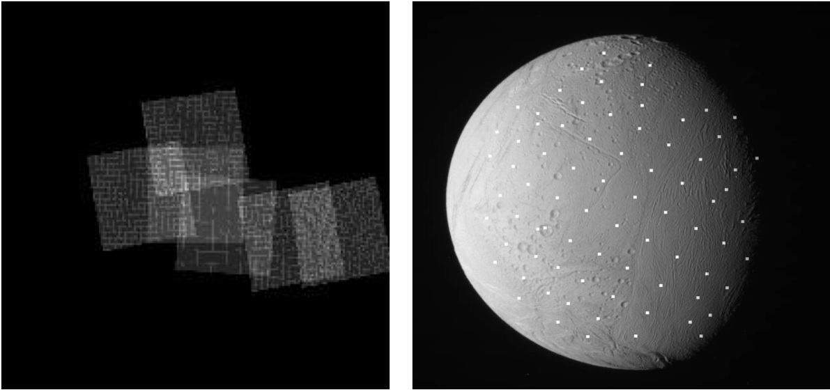
Specifying a Maplet
- Maplets specified by selecting control point based on
- (1) pixel, line position of a given image
- (2) Lat/Lon
- (3) Relative to local coordinates (x1, x2) of existing nearby maplet
- Setting scale (km/pix), #pixels/row
(1) => (p, l) mapped onto surface, control vector V determined by bi-linear interpolation from heights of nearest 4 vectors of a-priori topography. Same with (2), (3)
- Construct local tangent plane and set u3 normal to local surface
Interpolate heights from a-priori topography to maplet pixels => h(x1,x2)
Picture Description
- Left: empty placeholder maplet wrt which we select maplet centers
- Right: Control point distribution on Enceladus based on Lat/Lon
Extracting Image Data
- Automatically find all images that contain area of given maplet, whole or in part, based on the a-priori geometry
- Automatically filter candidate images based on number of criteria such as;
- Resolution ratio between maplet/image scale (typically 1/3 - x3)
- Range of off-nadir view angles at maplet center (typically up to 60 )
- Brightness threshold of portion of image extract
- Any number of images (3 - few hundreds) used
- Maplet pixels projected in focal plane and image brightness resampled on maplet pixels via bilinear interpolation
Dark & invisible pixels are ignored & pixel brightness rescaled
Xtracting Image Data With No A-Priori Topo Information
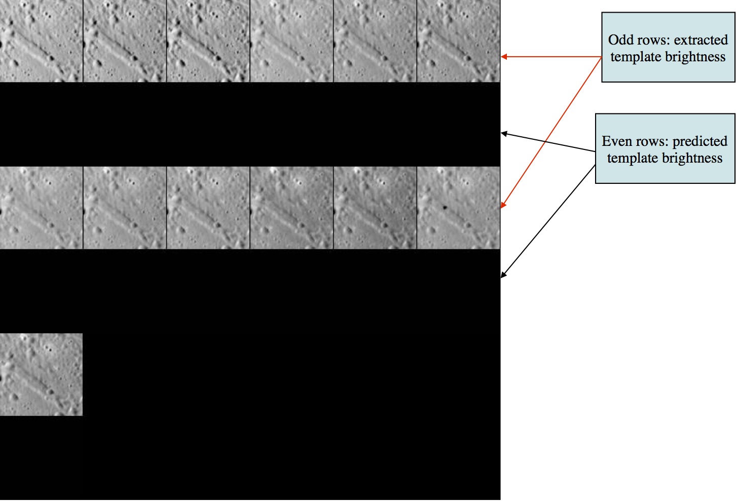
- Zero initial albedo
- Flat slopes from smooth sphere a-priori shape
- Predicted brightness is a near uniform value across template
Extracting Image Data With A-Priori Topo Information
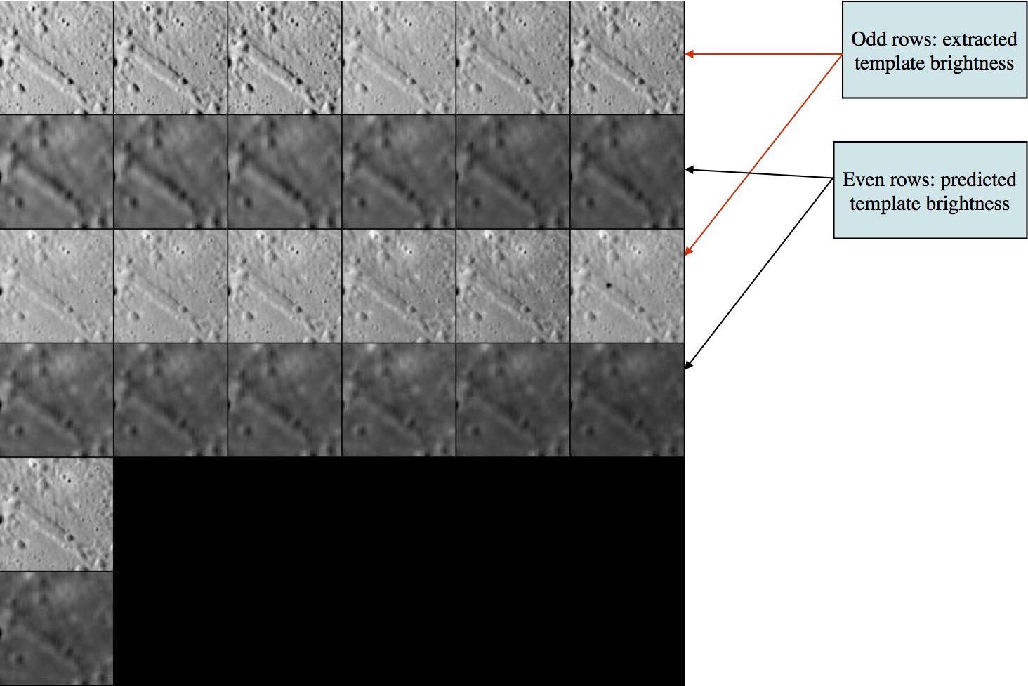
- Resampled images at 175 m/pix projected on existing low-res topography at 500 m/pix
- Predicted brightness is derived from that low resolution topography
