|
Size: 2927
Comment:
|
Size: 6287
Comment:
|
| Deletions are marked like this. | Additions are marked like this. |
| Line 1: | Line 1: |
| = Test nn: OptimalF2 = | = Test 05: OptimalF2 = == Aim and Objectives == |
| Line 5: | Line 7: |
| == Data == | '''Additional Objectives''' * To obtain user-in-the-loop and server-in-the-loop RMS error variations. * To obtain user-in-the-loop procedural variation. * To obtain beginner/expert user variation. == Methodology == '''Data''' |
| Line 8: | Line 17: |
| * Image Suite: Optimal flight path, resolutions: 50cm, 20cm, 10cm, 5cm. * emission * Every 20 degrees azimuth, 45 zenith angle * incidence * 0, 90, 180, 270, 45 zenith angle * 135 azimuth, 30 zenith angle |
* Image Suite: Optimal flight path, image resolutions: 50cm, 20cm, 10cm, 5cm. * S/C: * Every 20° azimuth angle, 45° zenith angle * Sun: * 0, 90°, 180°, 270° azimuth angle, 45 zenith angle * 135° azimuth angle, 30° zenith angle |
| Line 15: | Line 24: |
| The following TAG1 bigmaps were tiled and evaluated: | Spacecraft: {{attachment:SC_perfectF2_POLARS.jpg||width=300}} Sun: {{attachment:SUN_perfectF2_POLARS.jpg||width=300}} '''User/Server-in-the-loop:''' ||'''User'''||'''Experience'''||'''Server'''||'''Number of Core Processors'''|| ||TCampbell||Intermediate||?Ormacsrv2||?8|| ||KDrozd||Intermediate||Ormacsrv1||8|| ||DLambert||Beginner||Ormacsrv3||6|| ||EPalmer||Experienced||?||?|| ||JWeirich||Intermediate||DD||12|| '''Bigmaps''' The following TAG1 bigmaps were tiled/iterated and evaluated: Starting topography defined from: START1.MAP: * GSD = 25cm; * Q size = 150; * width = 75m; * center lat/wlong = -8.027, 262.768. '''DTM Bigmap parameters:''' ||Step||GSD(cm)||Overlap Factor||Approx. Overlap Percentage||Q Size||Width|| ||35cm-Tiling||35||1.3||60%||112||60m|| ||18cm-Tiling||18||1.3||60%||217||61m|| ||9cm-Tiling||9||1.3||60%||434||61m|| ||5cm-Tiling||5||1.3||60%||780||62m|| '''Evaluation Bigmap parameters:''' * GSD = 5cm; * Q size = 500; * width = 50m; '''Tiling Parameters''' Tiling parameters may have varied between users: ||Parameter||TCampbell||KDrozd||DLambert||EPalmer||JWeirich|| ||Image elimination: INVLIM||0||0||0||?||0|| ||Image elimination: SLIM||60 (@35cm), 50 (o.w.)||50||60 (@35cm), 50 (o.w.)||?||50|| ||Image elimination: CLIM||.5||.5||.5||?||.5|| ||Image elimination: ILIM||.5||.5||.5||?||.5|| ||Image elimination: RSMIN||0 (@35cm), .25 (o.w.)||.25||0 (@35cm), .25 (o.w.)||?||.25|| ||Image elimination: RSMAX||3||3||3||?||3|| ||Calculate Central Vector (v, 1)||YES||YES||YES||?||YES|| ||Differential Stereo (2, 6)||YES||YES||YES||?||YES|| ||Shadows (2, 7)||NO||NO||NO||?||NO|| '''Iteration Parameters''' Iteration parameters varied between users: ||Parameter||TCampbell||KDrozd||DLambert||EPalmer||JWeirich|| ||Reset albedo/slopes (a, y, y)||NO||YES||YES||?||YES|| ||Calculate Central Vector (v, 1)||YES||YES||YES||?||YES|| ||Differential Stereo (2, 6)||NO||NO||NO||?||NO|| ||Shadows (2, 7)||NO||YES||NO||?||YES|| |
| Line 18: | Line 90: |
Please see Tables and Figures. == Discussion == === User Differences in Tiling and Iteration Parameters === The only differences in tiling parameters pertain to the auto-elimination of images during the initial 35cm tiling. The maximum permissible emission angle varied between 50 and 60 degrees. The minimum allowable ration between image scale and misplace varied between 0 and 0.25. All other tiling step parameters were the same between users. Iteration parameters however varied greatly between users, with no two users applying an identical set of parameters. All users calculated the central vector (v1), however not all users reset albedo/slopes, conditioned with differential stereo and/or conditioned with shadows. === User Differences in Processing Steps === === User Differences in Evaluation Statistics === == Conclusions and Recommendations == == Tables and Figures == |
|
| Line 69: | Line 163: |
| '''35cm Maplets - 50cm Resolution Images''' | '''35cm GSD Maplets - 50cm Resolution Images''' |
| Line 71: | Line 165: |
'''18cm GSD Maplets - 20cm Resolution Images''' {{attachment:MTAG15-18cmMaplets.jpg}} '''9cm GSD Maplets - 10cm Resolution Images''' {{attachment:MTAG15-9cmMaplets.jpg}} |
Test 05: OptimalF2
Aim and Objectives
Purpose of test: To obtain highest possible topographic accuracy and resolution for TAG site 1, given perfect camera position and pointing and optimal SPC image suite.
Additional Objectives
- To obtain user-in-the-loop and server-in-the-loop RMS error variations.
- To obtain user-in-the-loop procedural variation.
- To obtain beginner/expert user variation.
Methodology
Data
- Data was generated by Imager_mg using shape3.8 on ormacsrv1.
- PT10A - Centered at the middle of TAG site one.
- Image Suite: Optimal flight path, image resolutions: 50cm, 20cm, 10cm, 5cm.
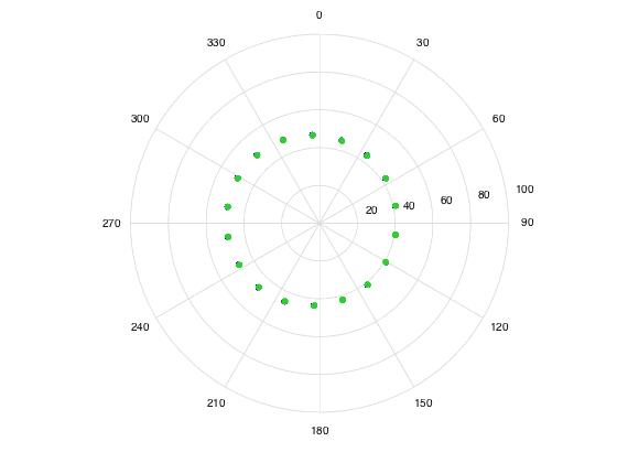
- S/C:
- Every 20° azimuth angle, 45° zenith angle
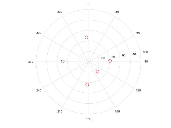
- Sun:
- 0, 90°, 180°, 270° azimuth angle, 45 zenith angle
- 135° azimuth angle, 30° zenith angle
- S/C:
Spacecraft:
Sun:
User/Server-in-the-loop:
User |
Experience |
Server |
Number of Core Processors |
TCampbell |
Intermediate |
?Ormacsrv2 |
?8 |
KDrozd |
Intermediate |
Ormacsrv1 |
8 |
DLambert |
Beginner |
Ormacsrv3 |
6 |
EPalmer |
Experienced |
? |
? |
JWeirich |
Intermediate |
DD |
12 |
Bigmaps
The following TAG1 bigmaps were tiled/iterated and evaluated:
Starting topography defined from: START1.MAP:
- GSD = 25cm;
- Q size = 150;
- width = 75m;
- center lat/wlong = -8.027, 262.768.
DTM Bigmap parameters:
Step |
GSD(cm) |
Overlap Factor |
Approx. Overlap Percentage |
Q Size |
Width |
35cm-Tiling |
35 |
1.3 |
60% |
112 |
60m |
18cm-Tiling |
18 |
1.3 |
60% |
217 |
61m |
9cm-Tiling |
9 |
1.3 |
60% |
434 |
61m |
5cm-Tiling |
5 |
1.3 |
60% |
780 |
62m |
Evaluation Bigmap parameters:
- GSD = 5cm;
- Q size = 500;
- width = 50m;
Tiling Parameters
Tiling parameters may have varied between users:
Parameter |
TCampbell |
KDrozd |
DLambert |
EPalmer |
JWeirich |
Image elimination: INVLIM |
0 |
0 |
0 |
? |
0 |
Image elimination: SLIM |
60 (@35cm), 50 (o.w.) |
50 |
60 (@35cm), 50 (o.w.) |
? |
50 |
Image elimination: CLIM |
.5 |
.5 |
.5 |
? |
.5 |
Image elimination: ILIM |
.5 |
.5 |
.5 |
? |
.5 |
Image elimination: RSMIN |
0 (@35cm), .25 (o.w.) |
.25 |
0 (@35cm), .25 (o.w.) |
? |
.25 |
Image elimination: RSMAX |
3 |
3 |
3 |
? |
3 |
Calculate Central Vector (v, 1) |
YES |
YES |
YES |
? |
YES |
Differential Stereo (2, 6) |
YES |
YES |
YES |
? |
YES |
Shadows (2, 7) |
NO |
NO |
NO |
? |
NO |
Iteration Parameters
Iteration parameters varied between users:
Parameter |
TCampbell |
KDrozd |
DLambert |
EPalmer |
JWeirich |
Reset albedo/slopes (a, y, y) |
NO |
YES |
YES |
? |
YES |
Calculate Central Vector (v, 1) |
YES |
YES |
YES |
? |
YES |
Differential Stereo (2, 6) |
NO |
NO |
NO |
? |
NO |
Shadows (2, 7) |
NO |
YES |
NO |
? |
YES |
Results
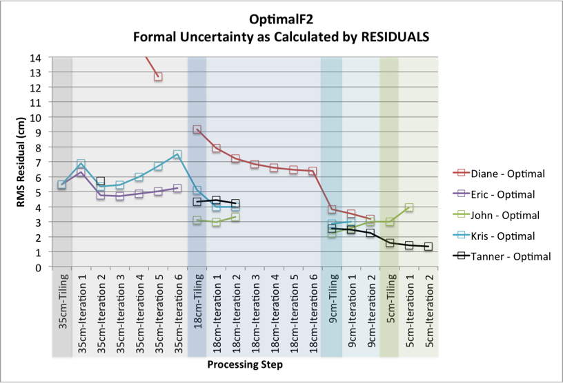
Please see Tables and Figures.
Discussion
User Differences in Tiling and Iteration Parameters
The only differences in tiling parameters pertain to the auto-elimination of images during the initial 35cm tiling. The maximum permissible emission angle varied between 50 and 60 degrees. The minimum allowable ration between image scale and misplace varied between 0 and 0.25. All other tiling step parameters were the same between users.
Iteration parameters however varied greatly between users, with no two users applying an identical set of parameters. All users calculated the central vector (v1), however not all users reset albedo/slopes, conditioned with differential stereo and/or conditioned with shadows.
User Differences in Processing Steps
User Differences in Evaluation Statistics
Conclusions and Recommendations
Tables and Figures
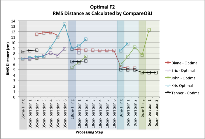
RMS Distance (cm) - Compare OBJ
Resolution (cm) |
Step |
Diane |
Eric |
John |
Kris |
Tanner |
35 |
35cm-Tiling |
|
7.06 |
|
7.06 |
8.35 |
35 |
35cm-Iteration 1 |
|
6.95 |
|
7.15 |
8.49 |
35 |
35cm-Iteration 2 |
11.51 |
7.15 |
7.13 |
7.44 |
8.58 |
35 |
35cm-Iteration 3 |
11.76 |
7.6 |
|
7.44 |
|
35 |
35cm-Iteration 4 |
11.85 |
8.04 |
|
9.10 |
|
35 |
35cm-Iteration 5 |
11.31 |
7.57 |
|
11.05 |
|
35 |
35cm-Iteration 6 |
|
8.81 |
|
13.39 |
|
18 |
18cm-Tiling |
8.78 |
|
5.43 |
8.79 |
6.49 |
18 |
18cm-Iteration 1 |
8.62 |
8.12 |
6.29 |
9.37 |
6.50 |
18 |
18cm-Iteration 2 |
8.57 |
|
7.45 |
10.60 |
6.58 |
18 |
18cm-Iteration 3 |
8.57 |
|
|
|
|
18 |
18cm-Iteration 4 |
8.56 |
|
|
|
|
18 |
18cm-Iteration 5 |
8.55 |
|
|
|
|
18 |
18cm-Iteration 6 |
8.54 |
|
|
|
|
9 |
9cm-Tiling |
5.47 |
|
6.00 |
8.49 |
4.98 |
9 |
9cm-Iteration 1 |
5.28 |
|
7.39 |
9.80 |
4.92 |
9 |
9cm-Iteration 2 |
5.27 |
|
9.15 |
|
4.92 |
5 |
5cm-Tiling |
|
|
7.68 |
|
4.47 |
5 |
5cm-Iteration 1 |
|
|
12.31 |
|
4.44 |
5 |
5cm-Iteration 2 |
|
|
|
|
4.45 |
Formal Uncertainty (cm) - RESIDUALS
Resolution (cm) |
Step |
Diane |
Eric |
John |
Kris |
Tanner |
|
35 |
35cm-Tiling |
|
5.48 |
|
5.49 |
|
|
35 |
35cm-Iteration 1 |
|
6.32 |
|
6.91 |
|
|
35 |
35cm-Iteration 2 |
29.78 |
4.76 |
|
5.36 |
5.72 |
|
35 |
35cm-Iteration 3 |
39.12 |
4.71 |
|
5.45 |
|
|
35 |
35cm-Iteration 4 |
14.74 |
4.87 |
|
5.98 |
|
|
35 |
35cm-Iteration 5 |
12.69 |
5.04 |
|
6.72 |
|
|
35 |
35cm-Iteration 6 |
|
5.23 |
|
7.51 |
|
|
18 |
18cm-Tiling |
8.78 |
9.17 |
|
3.12 |
5.11 |
4.34 |
18 |
18cm-Iteration 1 |
7.90 |
|
2.97 |
3.98 |
4.45 |
|
18 |
18cm-Iteration 2 |
7.23 |
|
3.33 |
3.98 |
4.22 |
|
18 |
18cm-Iteration 3 |
6.84 |
|
|
|
|
|
18 |
18cm-Iteration 4 |
6.61 |
|
|
|
|
|
18 |
18cm-Iteration 5 |
6.47 |
|
|
|
|
|
18 |
18cm-Iteration 6 |
6.40 |
|
|
|
|
|
9 |
9cm-Tiling |
3.82 |
|
2.24 |
2.86 |
2.54 |
|
9 |
9cm-Iteration 1 |
3.53 |
|
2.57 |
2.99 |
2.46 |
|
9 |
9cm-Iteration 2 |
3.18 |
|
3.01 |
|
2.26 |
|
5 |
5cm-Tiling |
|
|
2.99 |
|
1.59 |
|
5 |
5cm-Iteration 1 |
|
|
3.97 |
|
1.43 |
|
5 |
5cm-Iteration 2 |
|
|
|
|
1.35 |
35cm GSD Maplets - 50cm Resolution Images 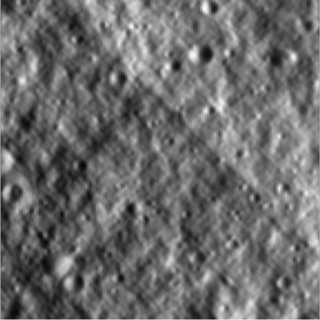
18cm GSD Maplets - 20cm Resolution Images 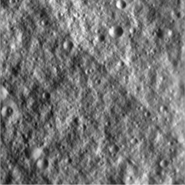
9cm GSD Maplets - 10cm Resolution Images 