Test09 OBoptimal
Goal
The point of this test was to evaluate how well SPC could create a bigmap of a tag site (1) using optimal imaging data from Orbit B. Optimal imaging data implies images taken of the tag site occur when the spacecraft and sun are at perfect azimuth and zenith angles so, that all parts of the tag site ( e.g. sides of craters & sides of boulders) could be captured out of shadow. RMS measurements from CompareOBJ that compare the SPC model with the truth model were used to judge the created Bigmap, along with traces and a heat map. Furthermore, the bigmap of the tag site was not the only bigmap evaluated. Five smaller bigmaps fore five Lockheed features respectfully were also evaluated.
Imaging Data
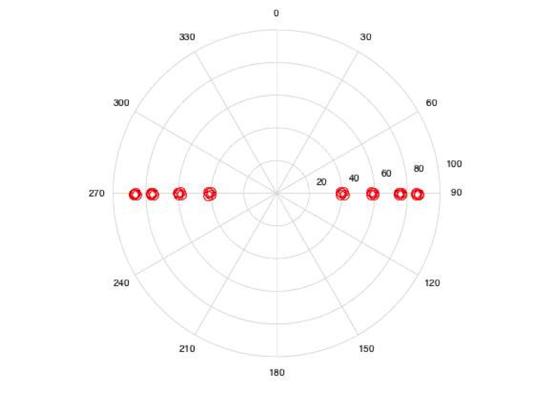
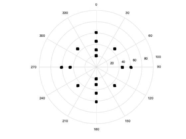
To replicate a terminator orbit trajectory (e.g. Orbit B), sun and spacecraft zenith angles during image capture were selected so that their sum equals 90 degrees. Also, many of the sun azimuth angles chosen are impossible, which was ignored during this test due to the assumption that the imaging data is perfect (We played God) for SPC with the only constraint being that the spacecraft has to be in a terminator orbit. A readme.txt file showing the image angle parameters for each image are shown below, along with the polars.
September 25, 2015
Kristofer Drozd

These Sumfiles and and Nominals were created for the first optimal orbit b test.

The optimal otbit b test is done to see what SPC can do with the best orbit b images.

Image Landmarks:
EE0011 (center of tag1 (3)) - -0.3295712733D-01    0.2614730241D+00   -0.3702992051D-01
EE0034 (3m north 3m west (1)) - -0.3097255801D-01    0.2617313664D+00   -0.3508827492D-01
EE0035 (3m north 3m east (2)) - -0.3798937978D-01    0.2617730236D+00   -0.3504279920D-01
EE0040 (3m south 3m west (4)) - -0.3106771623D-01    0.2593010950D+00   -0.4175064864D-01
EE0041 (3m douth 3m east (5)) - -0.3807991845D-01    0.2594780195D+00   -0.4172744156D-01

Code Inputs:
SC az (deg) - 0:45:315
SC z (deg) - 45
Sun az (deg) - 90:180:270
Sun z (deg) - 45
distance (km) - .8

SC az (deg) - 0:90:270
SC z (deg) - 60
Sun az (deg) - 90:180:270
Sun z (deg) - 30
distance (km) - .8

SC az (deg) - 0:180:180
SC z (deg) - 30
Sun az (deg) - 90:180:270
Sun z (deg) - 60
distance (km) - .8

SC az (deg) - 0:180:180
SC z (deg) - 20
Sun az (deg) - 90:180:270
Sun z (deg) - 70
distance (km) - .8
Sun Polar (EE0011): Azimuth vs. Zenith

SC Polar (EE0011): Azimuth vs. Zenith

Tagsite 1 Tiling Procedure
- A 9cm bigmap of tag site 1 was initialy loaded into the working directory for beginning topography. This was done to replicate a beginning model, similar to what we would achieve in flight from preliminary survey.
Eval
echo 1 .001 .001 | residuals &
/usr/local/localBin/bigMapRef < RTAG1C-center.in
/usr/local/localBin/bigMapRef < RTAGSC-single.in
/usr/local/localBin/bigMapRef < maps/MMAPL1.in
/usr/local/localBin/bigMapRef < maps/MMAPL2.in
/usr/local/localBin/bigMapRef < maps/MMAPL3.in
/usr/local/localBin/bigMapRef < maps/MMAPL4.in
/usr/local/localBin/bigMapRef < maps/MMAPL5.in
echo MMAPL1 | /usr/local/localBin/flatMapVec
echo MMAPL2 | /usr/local/localBin/flatMapVec
echo MMAPL3 | /usr/local/localBin/flatMapVec
echo MMAPL4 | /usr/local/localBin/flatMapVec
echo MMAPL5 | /usr/local/localBin/flatMapVec

# Save files
cp MMAPL*.TXT    MAPFILES/MTAG[1S]C.MAP  MAPFILES/MMAPL*.MAP      step##
cd MAPFILES

# Build and Evaluate main maplets
~/eval/bin/Maplet2FITS MTAG1C.MAP f;  ~/eval/bin/FITS2OBJ f mtag-1c.obj
~/eval/bin/Maplet2FITS MTAGSC.MAP f; ~/eval/bin/FITS2OBJ f mtag-sc.obj
~/eval/bin/CompareOBJ mtag-1c.obj ~/eval/bin/TTAG1L-25m2.5cm.obj
~/eval/bin/CompareOBJ mtag-sc.obj ~/eval/bin/TTAG1L-25m2.5cm.obj
~/eval/bin/CompareOBJ --compute-optimal-translation mtag-1c.obj ~/eval/bin/TTAG1L-25m2.5cm.obj
~/eval/bin/CompareOBJ --compute-optimal-translation mtag-sc.obj ~/eval/bin/TTAG1L-25m2.5cm.obj
~/eval/bin/CompareOBJ --compute-optimal-translation-and-rotation mtag-sc.obj ~/eval/bin/TTAG1L-25m2.5cm.obj
~/eval/bin/CompareOBJ --compute-optimal-translation-and-rotation mtag-1c.obj ~/eval/bin/TTAG1L-25m2.5cm.obj

# Convert Lockheed features obj
~/eval/bin/Maplet2FITS MMAPL1.MAP f ; ~/eval/bin/FITS2OBJ --local f lockheed1.obj
~/eval/bin/Maplet2FITS MMAPL2.MAP f ; ~/eval/bin/FITS2OBJ --local f lockheed2.obj
~/eval/bin/Maplet2FITS MMAPL3.MAP f ; ~/eval/bin/FITS2OBJ --local f lockheed3.obj
~/eval/bin/Maplet2FITS MMAPL4.MAP f ; ~/eval/bin/FITS2OBJ --local f lockheed4.obj
~/eval/bin/Maplet2FITS MMAPL5.MAP f ; ~/eval/bin/FITS2OBJ --local f lockheed5.obj

# Evaluate Lockheed features
~/eval/bin/CompareOBJ lockheed1.obj ~/eval/bin/TTAG1L-25m2.5cm.obj
~/eval/bin/CompareOBJ lockheed2.obj ~/eval/bin/TTAG1L-25m2.5cm.obj
~/eval/bin/CompareOBJ lockheed3.obj ~/eval/bin/TTAG1L-25m2.5cm.obj
~/eval/bin/CompareOBJ lockheed4.obj ~/eval/bin/TTAG1L-25m2.5cm.obj
~/eval/bin/CompareOBJ lockheed5.obj ~/eval/bin/TTAG1L-25m2.5cm.obj
