|
Size: 483
Comment:
|
Size: 2528
Comment:
|
| Deletions are marked like this. | Additions are marked like this. |
| Line 1: | Line 1: |
| Describe ReferencePeaks here. | Take PIT020 as the only maplet in MAPLIST.TXT. Generate 5cm images of the topography (which is based at TAG Site 1). Then we build a MAPLET, saving the MAPLETs flatMapVect at several states. |
| Line 4: | Line 4: |
| === Simple Variations === | |
| Line 12: | Line 12: |
| || base || Sun || S/C Az || S/C Zenith || || img || 45, 90, -45 || every 20 || 45 || || img || 45, 90, -45 || every 30 || 45 || || img || 45, 90, -45 || every 45 || 45 || || img || 45, 90, -45 || every 60 || 45 || || img || 45, 90, -45 || every 90 || 45 || || img || 45, 90, -45 || every 180 || 45 || |
=== Variations === Spacecraft Azimuth Variations || Sun || S/C Az || S/C Zenith || || 45, 0, -45 || every 20 || 45 || || 45, 0, -45 || every 30 || 45 || || 45, 0, -45 || every 45 || 45 || || 45, 0, -45 || every 60 || 45 || || 45, 0, -45 || every 90 || 45 || Sun Variations || Sun || S/C Az || S/C Zenith || || 30 || every 45 || 45 || || 30 -30 || every 45 || 45 || || -45, -45 || every 45 || 45 || || 30, 0, -30 || every 45 || 45 || || 45, 30, 0, -30, -45 || every 45 || 45 || || 60, 45, 30, 0, -30, -45, -60 || every 45 || 45 || || 60, 30, -30, -60 || every 45 || 45 || Spacecraft Zenith Variations || Sun || S/C Az || S/C Zenith || || 45, 0, -45 || every 45 || 0, 30, 60 || || 45, 0, -45 || every 45 || 0, 20, 40, 60, 80 || || 45, 0, -45 || every 45 || 0, 14, 30, 45, 60, 75 || === Hill Data === I have created the following hills for testing * PIT007 - 7 deg tilt * PIT014 - 14 deg tilt * PIT020 - 20 deg tilt <-- Let's use this one * PIT030 - 30 deg tilt * PIT045 - 45 deg tilt * PIT060 - 60 deg tilt === Truth Maplets === * Lat/Lon/Rad = -8.070 262.770 0.266 * Lat/Lon/Rad = -8.059 262.781 0.266 * TRU-##. Build a truth MAPLET using TAG Site 1 center position. Use the b option with a PIT###. === Testing Maplets === * Build a model MAPLET using TAG Site 1 center position. Do not load a base map for topography * Create MOD-## * Align the images with the key location at 50/50. * Build template with 100 * Do an auto align * Build height using the iteration template * Do flatMapVec and rename it to mod-##a * Repeat as necessary Iteration Template {{{ 0 0 44 2 8 fill no data with shape slope 7 .01 6 y y 2 condition with existing topo .01 6 y y 0 begin integration .025 100 0 v 1 u 1 }}} === Save States === Save the flatMapVect at the following * 1 * 2 * 3 * 5 * 10 * 15 * 20 === Examples === Example of a 14 degree peak, measured at difference locations {{attachment:14.png}} Example of a 20 degree peak, measured over time {{attachment:20.png}} |
Take PIT020 as the only maplet in MAPLIST.TXT. Generate 5cm images of the topography (which is based at TAG Site 1). Then we build a MAPLET, saving the MAPLETs flatMapVect at several states.
Simple Variations
Groups of images - (adjusted for 5cm)
- Detailed Survey
- Min Orbit B
- Average Orbit B
- Best Orbit B
- Optimum Collection
Variations
Spacecraft Azimuth Variations
Sun |
S/C Az |
S/C Zenith |
45, 0, -45 |
every 20 |
45 |
45, 0, -45 |
every 30 |
45 |
45, 0, -45 |
every 45 |
45 |
45, 0, -45 |
every 60 |
45 |
45, 0, -45 |
every 90 |
45 |
Sun Variations
Sun |
S/C Az |
S/C Zenith |
30 |
every 45 |
45 |
30 -30 |
every 45 |
45 |
-45, -45 |
every 45 |
45 |
30, 0, -30 |
every 45 |
45 |
45, 30, 0, -30, -45 |
every 45 |
45 |
60, 45, 30, 0, -30, -45, -60 |
every 45 |
45 |
60, 30, -30, -60 |
every 45 |
45 |
Spacecraft Zenith Variations
Sun |
S/C Az |
S/C Zenith |
45, 0, -45 |
every 45 |
0, 30, 60 |
45, 0, -45 |
every 45 |
0, 20, 40, 60, 80 |
45, 0, -45 |
every 45 |
0, 14, 30, 45, 60, 75 |
Hill Data
I have created the following hills for testing
- PIT007 - 7 deg tilt
- PIT014 - 14 deg tilt
PIT020 - 20 deg tilt <-- Let's use this one
- PIT030 - 30 deg tilt
- PIT045 - 45 deg tilt
- PIT060 - 60 deg tilt
Truth Maplets
- Lat/Lon/Rad = -8.070 262.770 0.266
- Lat/Lon/Rad = -8.059 262.781 0.266
- TRU-##. Build a truth MAPLET using TAG Site 1 center position. Use the b option with a PIT###.
Testing Maplets
- Build a model MAPLET using TAG Site 1 center position. Do not load a base map for topography
- Create MOD-##
- Align the images with the key location at 50/50.
- Build template with 100
- Do an auto align
- Build height using the iteration template
- Do flatMapVec and rename it to mod-##a
- Repeat as necessary
Iteration Template
0
0
44
2
8                fill no data with shape slope
7
.01
6
y
y
2                condition with existing topo
.01
6
y
y
0                begin integration
.025
100
0
v
1
u
1
Save States
Save the flatMapVect at the following
- 1
- 2
- 3
- 5
- 10
- 15
- 20
Examples
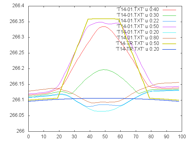
Example of a 14 degree peak, measured at difference locations 
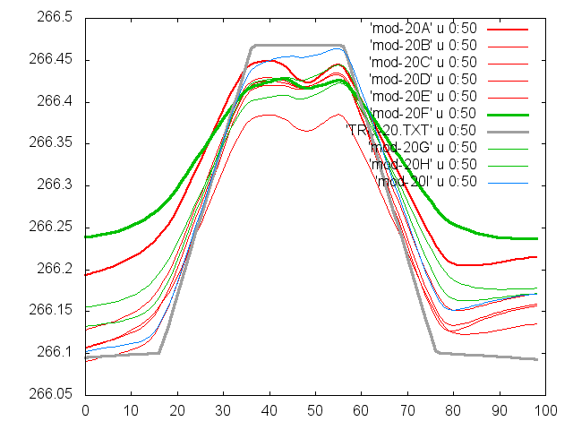
Example of a 20 degree peak, measured over time 
