|
Size: 2269
Comment:
|
Size: 4028
Comment:
|
| Deletions are marked like this. | Additions are marked like this. |
| Line 2: | Line 2: |
| ===== (Compiled by TC) ===== | |
| Line 4: | Line 3: |
| <<BR>> = BACK UP YOUR WORK BEFORE RUNNING GEOMETRY = <<BR>> |
{X} '''''BACK UP YOUR WORK BEFORE RUNNING GEOMETRY!''''' |
| Line 9: | Line 6: |
| Makes a surface by solving for the spacecraft position, spacecraft pointing, and Landmark locations. | This program makes a surface by solving for the spacecraft position, spacecraft pointing, and landmark locations. This procedure iterates the solutions for camera pointing and landmark vectors sequentially. |
| Line 11: | Line 8: |
| == Requires == | (./) add descriptions below copied from another entry except as shown here. == Required Files == |
| Line 14: | Line 12: |
| * [[PICTLIST.TXT]] | * [[PICTLIST.TXT]] - list of picture names generated by [[make_sumfiles]] |
| Line 19: | Line 17: |
| * [[SHAPE.TXT]] - This is the shape model that is stored in directory SHAPEFILES. | * [[SHAPE.TXT]] - This is the shape model that is stored in directory [[SHAPEFILES]]/. |
| Line 22: | Line 20: |
| == Input stdin == . 1: landmark vectors. . 2: camera pointing, scobj . 0: end. input operation list {{{ 120 }}} enter number of iterations {{{ 3 }}} use limbs for pointing? (y/n) {{{ y }}} continue? (y/n) {{{ n }}} == Output == |
== Output Files == |
| Line 54: | Line 26: |
| == Optional Files == (./) I added the following two lines and warnings based on Tanner's email. Please check for accuracy. * [[PICTLISTS.TXT]] - User-generated list of picture names. /!\ '''geometry''' will only use this file instead of [[PICTLIST.TXT]] if you specify it in [[INIT_LITHOS.TXT]] with GEOPIC='PICTLISTS.TXT'. * [[LMRKLISTR.TXT]] - User-generated restricted list of landmark names. /!\ '''geometry''' will only use this file instead of [[LMRKLIST.TXT]] if you specify it in [[INIT_LITHOS.TXT]] with GEOMAP='LRMKLISTR.TXT'. == User Warning == ''''' /!\ Always back up your work before using geometry.''''' == Using geometry == The inputs for '''geometry''' are: '''input operation list''' - Use these values: . 1: landmark vectors. . 2: camera pointing, scobj . 0: end. '''enter number of iterations''' - Input desired number. '''use limbs for pointing? (y/n)''' - Choose whether to use limbs in determining camera pointing. '''continue? (y/n)''' - Choose whether to do it all over again. Here are two samples that show '''geometry''' inputs: {{{ GEOMETRY 120<- do 1 followed by 2 30 <- do them 30 times y <- use limbs for pointing n <- stop when done GEOMETRY 20 <- do 2 only 10 <- do it 10 times n <- don't use limbs for pointing n <- stop when done }}} The default is to do these operations for all landmarks in [[LMRKLIST.TXT]] and all images in [[PICTLIST.TXT]]. If [[INIT_LITHOS.TXT]] contains a record {{{ GEOPI='filename1' or GEOMAP='filename2' }}} then the files used are reduced. "filename1" is used instead of [[PICTLIST.TXT]] and "filename2" is used instead of [[LMRKLIST.TXT]]. |
|
| Line 58: | Line 93: |
| * Spacecraft State - Position and orientation of spacecraft affects size and location of the body in an image. Errors are reflected by offsets of extracted image data from maplets for all maplets in the image. * Control Point Location - An error in the body-fixed control point location is reflected by offsets of extracted image data for all images containing the maplets. * Rotation - An error in the transformation from inertial to body fixed frames is reflected in time-dependent offsets in extracted image data for all maplets in all images. * Differential Stereo - Errors in the maplet heights relative to the center are reflected by differential shifts of features within the extracted image data in addition to displacements from the maplets themselves. |
* '''Spacecraft State''' - Position and orientation of spacecraft affects size and location of the body in an image. Errors are reflected by offsets of extracted image data from maplets for all maplets in the image. * '''Control Point Location''' - An error in the body-fixed control point location is reflected by offsets of extracted image data for all images containing the maplets. * '''Rotation''' - An error in the transformation from inertial to body fixed frames is reflected in time-dependent offsets in extracted image data for all maplets in all images. * '''Differential Stereo''' - Errors in the maplet heights relative to the center are reflected by differential shifts of features within the extracted image data in addition to displacements from the maplets themselves. |
| Line 65: | Line 101: |
| === More in Depth Description of Geometry === | === More Detailed Description of Geometry === |
| Line 75: | Line 111: |
---------- ''(Compiled by TC)'' CategoryPrograms |
geometry
 BACK UP YOUR WORK BEFORE RUNNING GEOMETRY!
Description
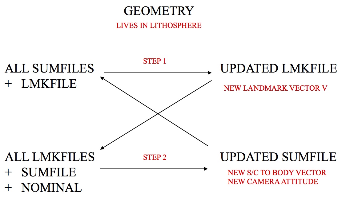
This program makes a surface by solving for the spacecraft position, spacecraft pointing, and landmark locations. This procedure iterates the solutions for camera pointing and landmark vectors sequentially.
![]() add descriptions below copied from another entry except as shown here.
add descriptions below copied from another entry except as shown here.
Required Files
PICTLIST.TXT - list of picture names generated by make_sumfiles
SHAPE.TXT - This is the shape model that is stored in directory SHAPEFILES/.
Output Files
Optional Files
 I added the following two lines and warnings based on Tanner's email. Please check for accuracy.
 PICTLISTS.TXT - User-generated list of picture names.
 geometry will only use this file instead of PICTLIST.TXT if you specify it in INIT_LITHOS.TXT with GEOPIC='PICTLISTS.TXT'.
 LMRKLISTR.TXT - User-generated restricted list of landmark names.
 geometry will only use this file instead of LMRKLIST.TXT if you specify it in INIT_LITHOS.TXT with GEOMAP='LRMKLISTR.TXT'.
User Warning
 Always back up your work before using geometry.
Using geometry
The inputs for geometry are:
input operation list - Use these values:
- 1: landmark vectors.
- 2: camera pointing, scobj
- 0: end.
enter number of iterations - Input desired number.
use limbs for pointing? (y/n) - Choose whether to use limbs in determining camera pointing.
continue? (y/n) - Choose whether to do it all over again.
Here are two samples that show geometry inputs:
 GEOMETRY
 120<- do 1 followed by 2
 30 <- do them 30 times
 y  <- use limbs for pointing
 n  <- stop when done

 GEOMETRY
 20 <- do 2 only
 10 <- do it 10 times
 n  <- don't use limbs for pointing
 n  <- stop when done
The default is to do these operations for all landmarks in LMRKLIST.TXT and all images in PICTLIST.TXT.
If INIT_LITHOS.TXT contains a record
GEOPI='filename1'

or

GEOMAP='filename2'
then the files used are reduced. "filename1" is used instead of PICTLIST.TXT and "filename2" is used instead of LMRKLIST.TXT.
PowerPoint Notes
Geometry Estimation Terms
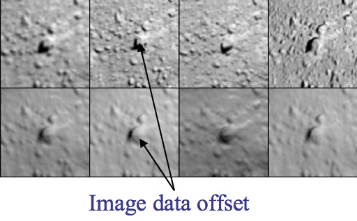
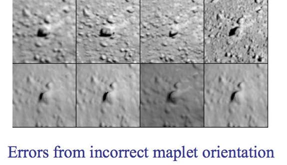
Spacecraft State - Position and orientation of spacecraft affects size and location of the body in an image. Errors are reflected by offsets of extracted image data from maplets for all maplets in the image.
Control Point Location - An error in the body-fixed control point location is reflected by offsets of extracted image data for all images containing the maplets.
Rotation - An error in the transformation from inertial to body fixed frames is reflected in time-dependent offsets in extracted image data for all maplets in all images.
Differential Stereo - Errors in the maplet heights relative to the center are reflected by differential shifts of features within the extracted image data in addition to displacements from the maplets themselves.


More Detailed Description of Geometry
- Global solution for camera pointing and body-fixed maplet location.
- Iterative process:
- Weighted least-squares solution of landmarks (control points) based on:
- Nominal camera pointing and position
- Relative landmark-to-landmark location
- Weighted least-squares solution of camera position and pointing based on landmark location
- Weighted least-squares solution of landmarks (control points) based on:

(Compiled by TC)
