|
Size: 1281
Comment:
|
← Revision 15 as of 2016-01-05 12:02:36 ⇥
Size: 1292
Comment:
|
| Deletions are marked like this. | Additions are marked like this. |
| Line 26: | Line 26: |
| If we want to accurately represent these large boulders, we will need better images. This may require additional image planning during the mission if we need to properly represent these large boulders. | If we want to accurately represent these large boulders, we will need higher resolution images. This may require additional image planning during the mission if we need to properly represent these large boulders. |
Test 01: First Boulder
Aim and Objectives
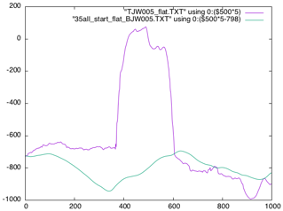
Purpose of test: Standard procedure was not creating accurate boulders (see transit below). The boulder was fuzzy, and there was actually a depression where the boulder was located. We wanted to see if tiling by hand could achieve a better solution.
 Purple is truth, green is model
Additional Objectives
- This was our first attempt at tiling by hand, so we were gaining experience with special cases.
Methodology
Procedures Start with a 35cm GSD and tile by hand. Step the GSD down by about a factor of 2 until reaching a 5cm GSD.
Data
- Approach and Detailed Survey images of Shape 3.7. Max image resolution was 5cm/pixel, GSD max of 5cm.
Results
- We tiled at higher and higher GSD, but we were not able to get to a high enough GSD to properly represent the boulder. The image pixel size was just not high enough to support the small maplets needed to properly represent the boulder.
Conclusions and Recommendations
- If we want to accurately represent these large boulders, we will need higher resolution images. This may require additional image planning during the mission if we need to properly represent these large boulders.
