Test F3F - Photometric Function

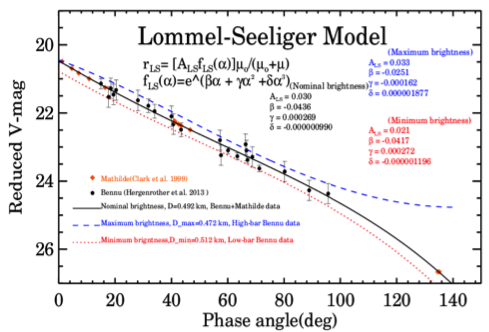
Goal: The photometric function of a surface is very difficult to constrain with a large number of physical processes and material types affecting it. Several models are routinely used to describe the photometric function within SPC (see above Figure). Here we will focus on the effect of three of them. While traditional 1D photoclinometry is highly dependent on the photometric model, SPC has other tools to reduce the effect of error in the photometric model and is not as sensitive to the exact photometric model being used. This test will demonstrate how much error remains in the shape depending upon which model and which form of which model is used. It will also evaluate if the rate at which the model converges is a function of the photometric function.
Test Set Up
Data: Approach, Preliminary Survey, and Detailed Survey PolyCam and MapCam Images:
- All NOMINALS and SUMFILES are perturbed as per F1A - Baseline.
- Detailed Survey Images:
Equatorial Stations MapCam images at approx. 30cm and 20cm pixel resolution.
Baseball Diamond Nadir (10am and 2pm stations) PolyCam images at approx. 5cm pixel resolution.
Baseball Diamond Off-Nadir (10am station looking at approx. 11am, and 2pm station looking at approx. 1pm) PolyCam images at approx. 5cm pixel resolution.
Start: 35cm Preliminary Survey Shape Model and 150cm, 75cm, and 35cm global maplets
Build:
- Extended TAG Site 1 (50x50m) at 20cm, centered at -8.027, 262.768 (lat, wlong).
- Extended TAG Site 1 (50x50m) at 10cm, centered at -8.027, 262.768 (lat, wlong).
- Extended TAG Site 1 (50x50m) at 5cm, centered at -8.027, 262.768 (lat, wlong).
- Evaluate 20mx20m region centered on TAG Site 1.
Sub-Test F3F-1
- Build shape based on Lommel-Seeliger without the 2.
- Run the model until the change in RMS between the truth model and the test model plateaus, expected to be about 50 iterations.
Sub-Test F3F-2
- Build shape based on Lommel-Seeliger with the 2
- Run the model until the change in RMS between the truth model and the test model plateaus, expected to be about 50 iterations.
Sub-Test F3F-3
- Build shape based on Clark's photometric phase function
- Run the model until the change in RMS between the truth model and the test model plateaus, expected to be about 50 iterations.
Test Procedures
Full test procedure details contained here: Test F3F-Photometric Function - Test Procedure.
Full processing states details contained here: Processing States.
Summary:
Start Model
Clean Start Model:
- Clean Start Model and run geometry (using standard photometric function (/usr/local/bin/LITHOS)).
Ingest Detailed Survey MapCam and PolyCam Images:
Ingest and register Detailed Survey MapCam and PolyCam images which cover a 100m x 100m region centered on TAG site 1.
Autoregister MapCam images to the 150cm, 75cm, and 35cm maplets in a 100m x 100m region centered on TAG site 1.
Sub-Test Model
Replace INIT_LITHOS.TXT with sub-test-specific version (for example support/INIT_LITHOS_mcewen.TXT for F3F1)
- DISCONTINUE USE OF STANDARD LITHOS AND LITHOSP - Use only:
- /SPC_Test/F3F-Photo/base/localbin/F3F-lithos;
- /SPC_Test/F3F-Photo/base/localbin/lithosP-F3F.
Iterate maplets contained in a 100m x 100m region centered on TAG site 1 (post ingest of Detailed Survey MapCam images).
- Clean until tiled and correlated states achieved.
- Generate and save evaluation files (EVAL20.MAP and MREF20.MAP).
20cm Tiling:
- Create a large BIGMAP at a resolution of 20cm with a width of 50m.
- Iterate maplets contained in a 100m x 100m region centered on TAG site 1.
- Clean until tiled and correlated states achieved.
- Generate and save evaluation files (EVAL20.MAP and MREF20.MAP).
10cm Tiling:
- Create a large BIGMAP at a resolution of 10cm with a width of 50m.
- Iterate maplets contained in a 100m x 100m region centered on TAG site 1.
- Clean until tiled and correlated states achieved.
- Run GEOMETRY, option 2 to update the position of the spacecraft.
- Iterate maplets contained in a 100m x 100m region centered on TAG site 1.
- Clean until tiled and correlated states achieved.
- Generate and save evaluation files (EVAL20.MAP and MREF20.MAP).
5cm Tiling:
- Create a large BIGMAP at a resolution of 5cm with a width of 50m.
- Iterate maplets contained in a 100m x 100m region centered on TAG site 1.
- Clean until tiled and correlated states achieved.
- Achieve imaged state.
- Achieve fitted state.
- Run GEOMETRY, option 2 to update the position of the spacecraft.
Clean:
- Achieve residualed state.
- Achieve re-tiled state.
- Achieve sigma'ed state.
- Generate and save evaluation files (EVAL20.MAP and MREF20.MAP).
Iteration:
- Repeat this section until RMS between the truth model and the test model plateaus
- Iterate maplets contained in a 100m x 100m region centered on TAG site 1.
- Clean until tiled and correlated states achieved.
- Generate and save evaluation files (EVAL20.MAP and MREF20.MAP).
Evaluate:
- Evaluate the accuracy of a 20mx20m region centered on TAG Site 1 at each tiling and iteration step.
- Consider the speed at which the solution converges (count number of iterations) for each sub-test.
