BIGFILES
Description
This directory stores bigmap .LMK files output by bigmap.
BIGFILES/ is a required directory for the program bigmap. A bigmap .LMK file of the same form as a maplet's landmark file (see LMKFILES for further details) is output by bigmap and stored in BIGFILES/.
Here is a sample BIGMAP/BIGMAP.LMK file:
T11RFU   T      0.2500  0.0500                                 NAME, HFLAG,
     200   0.0000100                                           SIZE, SCALE(KM)
        -1        -1        -1        -1                       HORIZON
    0.5000000000D-05    0.0000000000D+00                       SIGKM, RMSLMK
   -0.3192561939D-01    0.2620033289D+00   -0.3602428203D-01   VLM
    0.1295275799D-01   -0.1601986158D+00   -0.9869998123D+00   UX
   -0.9967472254D+00   -0.8059136793D-01    0.0000000000D+00   UY
   -0.7954366505D-01    0.9837893248D+00   -0.1607214063D+00   UZ
    0.1000000000D-04    0.1000000000D-04    0.1000000000D-04   SIGMA_LMK
PICTURES
P3T11U2H0665    451.96    554.55                               IMAGE, PIXEL/LINE LOCATION OF BIGMAP
P3T11U2H0666    451.96    554.55

P3T11U2H0848    533.59    474.26
P3T11U2H0849    523.75    488.41
P3T11U2H0850    523.75    488.41
P3T11U2H0851    523.75    488.41
P3T11U2H0852    523.75    488.41
MAP OVERLAPS
LIMB FITS
END FILE
(Compiled by DL)
DATA
Description
This directory stores the SPICE kernels used by SPC.
More information about the needed files to compute the spacecraft position and pointing in body fixed frame and the camera field of view can be found at the NAIF website.
(Compiled by KD)
IMAGEFILES
Description
IMAGEFILES/ stores images that will be used in SPC. These images are created by process_fits, which is different for every flight mission.
The data stored in each image file contained in the IMAGEFILES/ directory is a scaled unsigned integer (2 bytes or 16 bits), with the exclusion of values less than 0. Acceptable values are from 0 to 32767.
If the source is a real (or 32-bit float) value process_fits takes the original images' data float and calculates the maximum value. Then it scales the data to spread from 0 to 32767 to maximize the accuracy of the stored data.
(Compiled by KD)
LMKFILES
Description
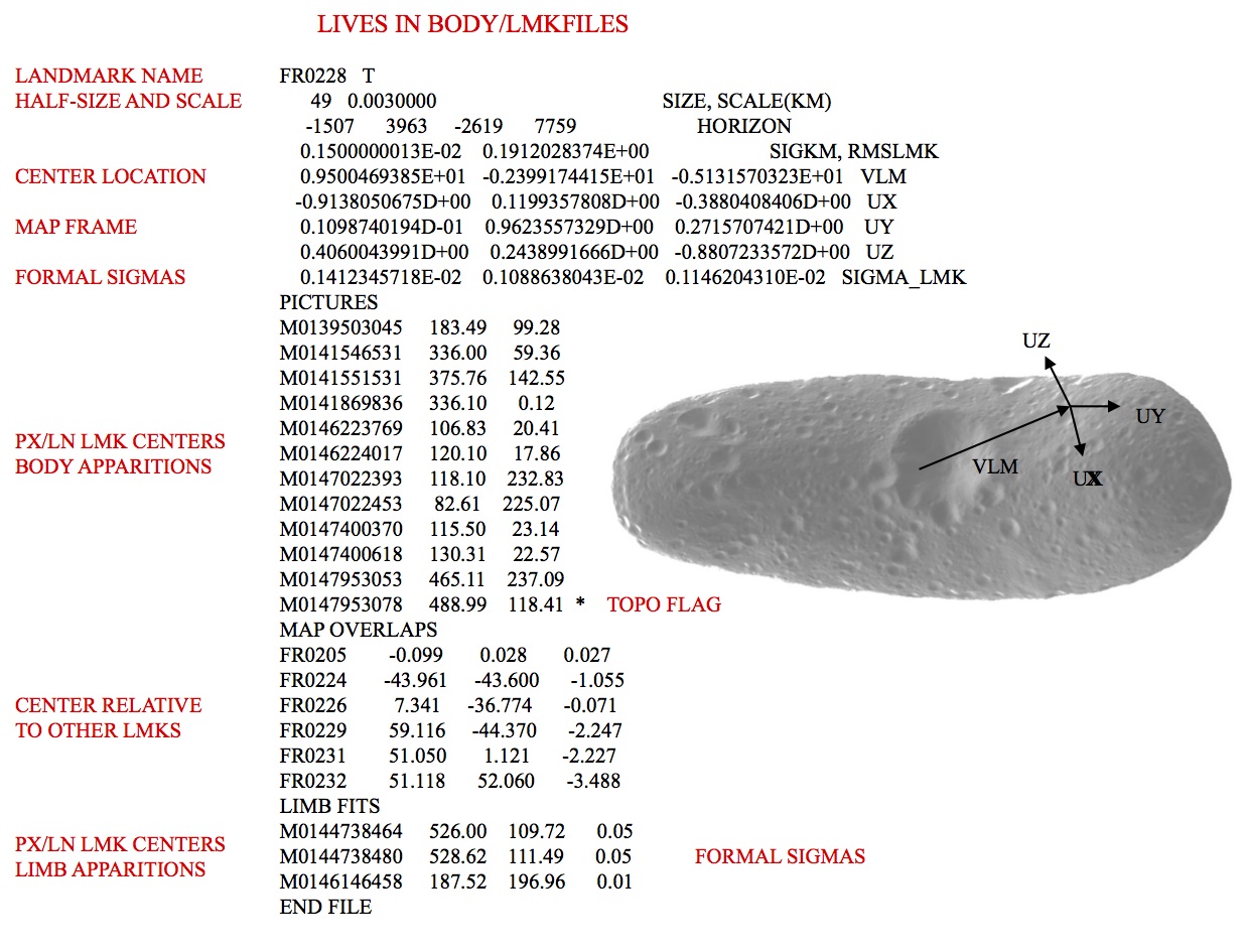
This directory stores landmark files, or "lmkfiles" created by lithos.
Each landmark file contains all the pertinent information about that landmark:
- name
- resolution
- half-size
- body-fixed central radial vector
- local orthogonal coordinate basis
- pixel/line location for each image it occurs in.
- Horizon is no longer used
By default, landmark files have the same name as their complimentary maplet files located in the MAPFILES directory. Maplets contain all of the topographical information, while landmark files contain all the corresponding position and pointing information.
Here is a sample of a landmark file:
EE0425   T                                                     NAME, HFLAG (lithos internal parameter)
      49   0.0000100                                           SIZE, SCALE(KM)
        -1        -1        -1        -1                       HORIZON
    0.5000000000D-05    0.0000000000D+00                       SIGKM, RMSLMK
   -0.2626299087D-01    0.2627170561D+00   -0.3160095548D-01   VLM
    0.6293765735D-02   -0.1377471387D+00   -0.9904474616D+00   UX
   -0.9982943535D+00   -0.5835403129D-01    0.1771996613D-02   UY
   -0.5804068595D-01    0.9887469411D+00   -0.1378794611D+00   UZ
    0.4293590936D-03    0.5209407279D-03    0.4297898945D-03   SIGMA_LMK
PICTURES
P3T11L2H0201    466.27    128.14
P3T11L2H0202    466.26    128.14
P3T11L2H0203    294.45    152.24
P3T11L2H0204    294.46    152.27
P3T11L2H0205    556.00    171.85
P3T11L2H0206    556.00    171.85
P3T11L2H0207    244.02    407.90
P3T11L2H0208    244.02    407.87
P3T11L2H0209    154.69    616.37
P3T11L2H0210    154.68    616.35
P3T11L2H0211    136.93    706.14
P3T11L2H0212    136.93    706.13
P3T11L2H0213    221.55    727.08
P3T11L2H0214    221.56    727.08
P3T11L2H0215    638.11    224.34
P3T11L2H0216    638.11    224.34
MAP OVERLAPS
EE0397        66.076       0.078      -0.250
EE0424         0.111      66.211       1.230
EE0426        -0.585     -66.961      -0.113
EE0453       -66.664      -0.151      -0.128
LIMB FITS
END FILE- MAP OVERLAP coordinate system (x, y, z) is in units of landmark GSD.

Figure 00: Landmark File Information Illustration
(Compiled by TC)
MAPFILES
Description
This directory contains all of the maplets and bigmaps that have been created.
mapfile Contents
Each mapfile contains a short header that looks like this:
 # Qsize           49
 # Scale    9.9999997473787516E-006
 # Vector   -2.6262991130352020E-002  0.26271706819534302       -3.1600955873727798E-002
 # Ux    6.2937657348811626E-003 -0.13774713873863220      -0.99044746160507202
 # Uy  -0.99829435348510742       -5.8354031294584274E-002   1.7719966126605868E-003
 # Uz   -5.8040685951709747E-002  0.98874694108963013      -0.13787946105003357
The mapfile header outlines basic information about the maplet (half-size, scale, central vector, coordinate frame) as well as the height and albedo values for each maplet pixel.
The mapfile is made up of 72 byte records. The first record contains information describing the size, scale, orientation and position of the map as listed here:
bytes 1-6 - Unused
bytes 7-10 - Scale in km/pixel (real*4 msb)
bytes 11-12- qsz where map is 2*qsz+1 x 2*qsz+1 pixels (unsigned short lsb)
bytes 16-27 - map center body fixed position vector in km 3 x (real*4 msb)
bytes 28-39 - Ux body fixed unit map axis vector 3 x (real*4 msb)
bytes 40-51 - Uy body fixed unit map axis vector 3 x (real*4 msb)
bytes 52-63 - Uz body fixed unit map normal vector 3 x (real*4 msb)
bytes 64-67 - Hscale = maximum abs(height)/30000 (real*4 msb)*
byte 13255* - X position uncertainty unit vector component (byte) +
byte 14255* - Y position uncertainty unit vector component (byte) +
byte 15255* - Z position uncertainty unit vector component (byte) +
bytes 68-71 - magnitude of position uncertainty (real*4 msb) +
byte 72 - Unused
* heights are in units of map scale
+ these are pretty much unused as far as I can see--how to word?
The remaining records are made up of 3 byte chunks:
bytes 1-2 - height/hscale (integer*2 msb)
byte 3 - relative "albedo" (1-199) (byte)
If there is missing data at any point, both height and albedo are set to zero.
(Compiled by TC)
NOMINALS
Description
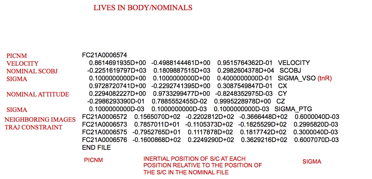
This directory stores the starting solution of an observation that is created from the executable make_sumfiles.
Each image has its own "nominal" file stored in the NOMINALS directory. These files have the image name with the suffix ".NOM". Nominal files do not update with the use of SPC (the "v 4" command in lithos), unlike sumfiles.
All vectors are in body fixed frame.
Nominals include:
Image name
Frame reference - Inertial s/c velocity unit vector that defines the downtrack direction. The label is the frame used for SIGMA_VSO.
SCOBJ - S/C to object vector -- [units km] (This can be in inertial frame, or body fix position.)
SIGMA_VSO - Error in S/C position -- [units km]
Cx, Cy, Cz - Camera pointing vectors in the body frame.
SIGMA_PTG - Error in camera pointing -- [units rad]
 There are entries for DYNAMICS that list the previous 2 and following 2 images' relative positions. These are used to condition the S/C position when running GEOMETRY, option 2.
Here is a sample of a nominal file:
S595057374F1
   -0.3635326241D+00   -0.9250382113D+00   -0.1102195033D+00   BOD_FRAME
    0.3071334125D+00    0.4756036668D+02   -0.3008768662D+01   SCOBJ
    0.1000000000D+01    0.1000000000D+01    0.1000000000D+01   SIGMA_VSO
    0.9685067274D+00    0.3109628683D-02    0.2489679684D+00   CX
    0.2486662018D+00   -0.6285289007D-01   -0.9665477920D+00   CY
    0.1264275161D-01    0.9980179580D+00   -0.6164670642D-01   CZ
    0.1000000000D-02    0.1000000000D-02    0.1000000000D-02   SIGMA_PTG
END FILE
Figure 00: Nominal File Illustrating the Starting Solution
(Compiled by KD)
SHAPEFILES
Description
This directory stores shape files. Out of the many shape files that can be stored in SHAPEFILES, SPC only uses one shape model at a time, SHAPE.TXT. It is the main shape model used throughout SPC.
The first line of SHAPE.TXT is the Q size (between 8 and 512 in a factor of 2 increments: 8, 16, 32, 64, 128, 256, 512). The shape is in the ICQ format, which is basically a 6-sided cube. The number of vertices in the shape file is 6 * (Q+1)^2, so the number of lines in the shape file will be one higher.
Each subsequent line gives the vector of the surface. The vectors are in Cartesian space (x, y, z).
SHAPE00.TXT is the "baseline" shape model. This can be used to keep track of how different it becomes from the starting shape. Usually, it is turned off partway through the mission by INIT_LITHOS.TXT.
 Use a symbolic link to specify SHAPE.TXT. This way, you can keep a useful filename in the directory, but "link" it to SHAPE.TXT so that SPC runs properly.
Here is a sample set of commands to show how to set up a link:
cd SHAPEFILES
ln -s <realfile> SHAPE.TXT
Here is a sample of a shape model:
         512
  -278.04003   278.04003   268.57872
  -276.88948   278.59369   269.11354
  -275.73912   279.14388   269.64501
  -274.58894   279.69061   270.17314
  -273.43898   280.23391   270.69794
  -272.28923   280.77377   271.21943
  -271.13971   281.31022   271.73763
  -269.99043   281.84328   272.25255
  -268.84141   282.37296   272.76420
  -267.69265   282.89927   273.27260
...
(Compiled by KD)
SUMFILES
Description
This directory stores sumfiles.
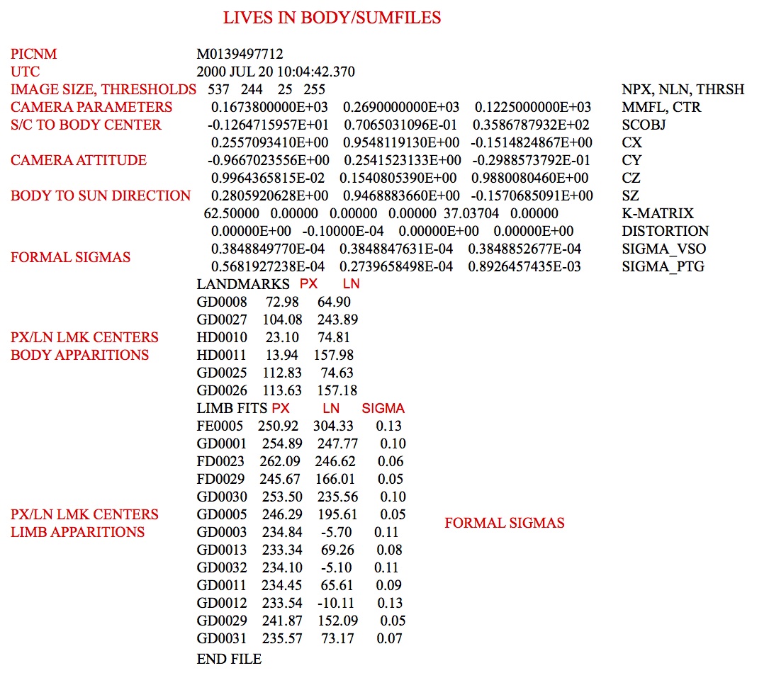
A "sumfile" is created by the executable make_sumfiles. It contains the following information about its image:
- camera data
- target-relative position vectors
- pointing vectors
- uncertainty values
- landmark info
There is only one sumfile for each image. SPC uses data from sumfiles throughout various executables such as lithos. As you use SPC to correlate images with lithos, you can update the sumfile vectors and landmark lists using the "v 4" command (see lithos).
Unlike nominals, sumfiles can change throughout SPC usage.
The sumfiles crated by make_sumfiles are named as <image name>.SUM and placed in a directory titled SUMFILES within the user's working directory.
Here is a sample of a sumfile:
W46908480918                                                                           # image name
2014 NOV 12 17:20:03.128                                                               # utc
  2048  2048   500 65535                                       NPX, NLN, THRSH         # pic size, lower and upper dn thresholds
    0.1356800000D+03    0.1044000000D+04    0.9380000000D+03   MMFL, CTR               # focal length, px/ln center (boresight/optical axis)
   -0.9665063720D+01    0.1326644487D+02   -0.6673084308D+01   SCOBJ                   # s/c-object vector (body fixed)
   -0.6442479111D+00   -0.1829032409D-01    0.7645979944D+00   CX                      # pixel unit vector (body fixed)
    0.5935707119D+00    0.6184779444D+00    0.5149357652D+00   CY                      # linel unit vector (body fixed)
   -0.4823053379D+00    0.7855892670D+00   -0.3875965231D+00   CZ                      # boresight unit vector (body fixed)
    0.7254908676D+00   -0.3292717307D+00    0.6043534796D+00   SZ                      # sun unit vector (body fixed)
  74.07410   0.00000   0.00000   0.00000  74.07410   0.00000   K-MATRIX
    0.00000D+00    0.00000D+00    0.00000D+00    0.00000D+00   DISTORTION              # always zero these days (distortion comes in elsewhere)
    0.1007758363D-02    0.1482813397D-02    0.8902614968D-03   SIGMA_VSO               # formal scobj uncertainty
    0.3071768580D-04    0.3093941486D-04    0.1565302183D-04   SIGMA_PTG               # formal pointing uncertainty
LANDMARKS
AO0001   2049.39    668.15
AO0002   2020.70    644.81
AO0003   2035.17    708.66                                                             # landmark px/ln centers
BD0009   1902.39    884.05
BD0010   1891.13    909.86
   ...
EK0022    675.73   1371.97
EQ0088    721.76    738.13
FI0002    727.77    220.40
LIMB FITS                                                                              # landmark-on-limb centers (none here)
END FILE
Comments (information after the #) were added here for clarification and are not included in an actual sumfile.
Here is another sample sumfile:

Figure 00: SUMFILES Information Illustration
(Compiled by KD)
TESTFILES
Description
This directory stores output display files for user inspection during batch processing.
The following table explains which script-makers and run scripts use the TESTFILES/ directory and the display files stored in the directory by their display file source programs:
Table 00: Listing of Scripts Using the TESTFILES Directory
Script-Maker |
Run Script |
Display File |
Display File Source |
Batch Processing Description |
run_script.b |
LMRK_DISPLAY1.pgm for each image |
Batch autoregistration of images. |
||
run_script.b |
LMRK_DISPLAY1.pgm for each landmark |
Batch lithos processing of landmarks. |
||
run_script.b |
LMRK_DISPLAY.pgm for each image |
Batch registration of images. |
||
run_script.b |
LMRK_DISPLAY1.pgm for each landmark |
Tiling of a bigmap or shape with a suite of new landmarks. |
(Compiled by DL)
TESTFILES1
Description
This directory stores display files for user inspection during batch processing.
The following table explains which script-makers and run scripts use the TESTFILES1/ directory and the display files stored in the directory by their display file source programs:
Table 00: Listing of Scripts Using the TESTFILES1 Directory
Script-Maker |
Run Script |
Display File |
Display File Source |
Batch Processing Description |
run_scriptnn.b |
LMRK_DISPLAYnn.pgm for each image |
Batch autoregistration of images using parallel processing. |
||
run_script.b |
tmpl.pgm for each landmark |
Batch lithos processing of landmarks. |
||
run_scriptnn.b |
LMRK_DISPLAYnn.pgm for each landmark |
Batch iteration of landmarks using parallel processing. |
||
run_script.b |
tmpl.pgm for each landmark |
Tiling of a bigmap or shape with a suite of new landmarks. |
(Compiled by DL)